Quantcast
Channel: Carmen and Conquest
Viewing all 47 articles
Browse latest View live

1066 as a Catholic Crusade: Ports, Sees and Crowns

$
0
0

One of the patterns I found while researching the Carmen was the "First Christian King" pattern.  Maybe historians have already written hundreds of papers on this, but I stumbled on it as an observation, so that's how you get it here.  Like everything Roman there was a system for subjugation of client kings and the Roman system set the standards for first Christian kings in the Roman Catholic Church.  It turns out the church took possessions it received from first Christian kings very seriously, and these possessions became key territorial objectives of the Norman Conquest in 1066.

Only kings consecrated by the Catholic Church with the consent of the pope were deemed royal with rights of inheritance for their heirs in the early medieval era.  Kings sought papal approval and holy consecration to gain legitimacy and protection from challenge of rival tribal lords and neighbouring kings.  The first Christian king of just about anywhere you can name in Europe will have three things in common with other first Christian kings: (1) He was approached by a missionary sent by a pope to convert him to Christianity; the missionary baptised him and established Christianity in his realm.  (2) The king founded a priory for the care of his immortal soul in the Holy See, giving land and the revenues of an extraterritorial and inviolable canton port to the monks of the new religious order, usually Benedictines.  (3) The king founded a bishopric for a native church with an episcopal see; the see was granted liberties and revenues of a market borough so that the native church, bishops and priests might prosper and convert pagans to Christianity.  The Roman Empire had incredibly efficient systems for promoting and controlling trade and markets as the portorium and vectigalia were the principal means of streaming money from provinces to Rome.  The Roman Catholic Church church took these systems and leveraged them into a stream of secular revenues for the church and Holy See that in parallel promoted the concentration of wealth and power in the Christian royal kings.  If you think of it as a Mafia-style protection racket, you won't be far wrong.

In England the first Christian king was King Lucius, converted sometime around 180.  According to legend he wrote to Pope Eleutherius asking to become a Christian, and the pope sent missionaries Fuganus and Duvianus to baptise the king and establish a Christian church in England.  King Lucius then founded a priory in the Holy See at Dover for the care of his immortal soul, endowing Christ Church inside the old Roman castle as a priory with revenues of the port.  He founded the archbishopric of England in London with a church for the episcopal see at St Peter-upon-Cornhill; its first bishop was Thean.  Lucius founded other churches for other bishoprics including the Old Minster at Winchester and St Martin's church in Canterbury - each with the lands and liberties of the borough flamens for support of the church's good works and the spread of Christianity in the diocese.  King Lucius reigned for 77 years, including 54 years after his baptism, and was buried in London at his death.  After his death Christianity faded again, under attack by Romans and pagans alike, and the English church lapsed in the 4th century.

In 496 Pope Gregory sent Augustine, Mellitus and Justus with 40 monks to bring Christianity again to Britain.  King Aethelberht of Kent was married to Bertha, a Frankish princess and Christian from across the Channel, and she sought to bring Christianity to her husband's kingdom.  Augustine delivered his brothers from a tempest into the port of Wincenesel, and they danced and sang in gratitude at their deliverance.  King Aethelberht was baptised a Christian, founded a priory in the Holy See with revenues of a port, and founded a bishopric at Canterbury to be the see of Kent with Augustine as the first archbishop of Canterbury, moving the archbishop's episcopal see and control of the English church from London to Canterbury.

Mellitus then converted King Saeberht of the East Saxons to Christianity, and like all first Christian kings, King Saeberht founded an abbey with a port for the Holy See and a bishopric with a see for a native church.  The abbey was consecrated to St Paul in the Roman port of London, known then as East Minster and believed the site of the earlier church granted by King Lucius.  The episcopal see was consecrated to St Peter on Thorn Island, known afterwards as West Minster.  Mellitus was ordained the first bishop to the new see at St Peter’s Westminster in 604.  Mellitus fled to Gaul after King Saeberht's death as his pagan sons sacked Westminster and London in 617.  Although Mellitus returned as archbishop of Canterbury, no bishop returned to London for fifty years, and when Wine was made bishop of London in 666 he took refuge within the city's strong walls at Old St Paul's abbey church, making it the episcopal see by usage rather than endowment, and confusing royal and Holy See jurisdictions.

Aethelberht's daughter, Aethelburg, married King Edwin of Northumbria, and by  627 Paulinus, the monk who accompanied her north, had converted Edwin and a number of other Northumbrians.  Like all first Christian kings, King Edwin founded an order in the Holy See to pray for his immortal soul with revenues of a port at Lindesfarne and a bishopric with a see supported by borough market and liberties at York with Paulinus as the first archbishop.

King Cenwalh of Wessex converted to Christianity about 648, establishing a see for the diocese of Wessex at the site of the church founded by King Lucius in Winchester, which became the Old Minster and later Winchester Cathedral.  He founded a Benedictine religious order in the Holy See and gave them the Isle of Wight with port privileges for the care of his soul.  King Alfred the Great would later establish a priory in the Holy See at Winchester, the New Minster, confusing royal and Holy See jurisdictions in the borough. 

In the 8th century King Offa unified the kingdoms of England by conquering the East Saxons, Hastingas and Wessex and merging these three distinct regions with his native Mercia.  His powerful wife Cynethreth was a Frankish kinswoman of Charlemagne, and the queen and his adviser Alcuin urged alignment with the pope and adoption of Frankish commercial administration and trade.  King Offa sent to the pope to seek consecration as king of the united realm, later visiting Rome himself on pilgrimage.  He confirmed a priory for Saint Denys at Rotherfield with the port of Hastingas & Pevenisel, known as Wincenesel to the Benedictines, and also granted the same order land on the strand at Lundenwick, the port of London.  He founded a see for a new bishopric at Lichfield for the benefit of his the northern kingdom.  Vikings had begun to raid England and had overwintered for the first time in England the year before, so perhaps King Offa was keen to secure alliance with the Roman pope and the Frankish emperor to better defend England against the Vikings and the Danes.

The Danes were not easily dissuaded from settlement and raiding in England and over the succeeding centuries more and more Danes settled in England.  First the Danes settled in the north and east, creating Danelaw - a region under Danish hegemony.  Then the Anglo-Danes of the north of England continued raiding in the south, demanding tribute from the English kings.   King Aethelred decided he needed big, bad allies to take on the Danes so he married Emma of Normandy in 1002, making her queen with primacy for her sons as legitimate heirs to the crown.  A few months later he ordered the killing of every Danish man, woman and child in England on St Brice's Day.  Among the dead was the sister of King Sweyn of Denmark and he started invading England the next year.  King Aethelred died in 1016, his son Edmund Ironside was defeated and died a few months later.  King Cnut the Great married the widowed Queen Emma in 1017.  King Cnut and his Danes and Anglo-Danes raided and enslaved widely in England, including taking possession of ports, lands and treasures belonging the church.  King Cnut still wanted Rome's legitimacy, however, so he gave a charter of protection to London to secure consecration as king of England in 1016 and a charter of protection to the manors of Hastingas and Pevenisel to secure consecration of Emma as queen of England in 1017.  Both London and Portus Hastingas & Pevenisel remained Holy See jurisdictions with exterratoriality and inviolability.  The Roman Catholic Church, which controlled all international trade ports in Christian realms, would have insisted that trade with England be directed to the ports it controlled in England and the ports at London, the Isle of Wight and Hastingas would then become hugely prosperous during the decades of King Cnut's rule of England.  The frequency with which Godwin and his sons raid the Isle of Wight, Pevensel and Hastingas during their rebellions against Edward the Confessor and each other are testimony to the appeal of Holy See ports as prosperous targets.

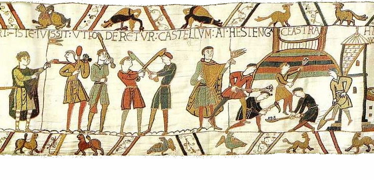
Bringing this back to the Carmen and 1066, William the Conqueror landed at Wincenesel in the port of Hastingas & Pevenisel - also known by then as Hastingaport - the very port said to have welcomed St Augustine and his chums.  After the Battle of Hastings when William had become lord of England by defeating and burying the excommunicate and unconsecrated King Harold under a heap of stones on the coast, he began to secure possession of the royal realm.  He marched to Dover and took possession of Dover and its port and castle, where he remained 30 days.  Envoys were sent to Canterbury and the archepiscopal see of the Church of England sent the first tribute, followed by all other urban boroughs in canonical and royal duty.  Then William marched to Winchester where the primates (the bishop of the see in Old Minster and the abbot of the abbey in New Minster) and Queen Edith, relic of King Edward the Confessor, all agree a deal offered by King William: they will accept him as king and swear loyalty, but they will only pay him market tolls - vectigalia - and not poll taxes - tributa.  Then William marches on London where the rebels have taken sanctuary and a Witenagemot has convened to make Edgar the Aethling a figurehead king.  King William guarantees the burgesses of London will retain their independent republican governance and generous liberties and they agree to renounce Edgar and swear oaths of loyalty to King William.  The bishop who holds the king's right hand in procession to Westminster is Archbishop Ealdred of York while his left hand is held by "another equal in rank", referring to the metropolitan Bishop William of London, just as London and York were deemed equal by Pope Gregory in the 6th century.

Wincenesel - a Holy See port.  Dover - a Holy See port.  Canterbury - the archbishopric of all the church of England.  Winchester - the see of the bishopric of Wessex and a Holy See borough.  London - the see of the bishopric of the East Saxons and a Holy See port.  London and York equal metropolitan bishoprics in canonical law.  Anyone else see a relevant pattern here?

The church wanted Dover back even before 1066.  Return of Dover castle was part of the oath Earl Harold swore to Duke William in 1064 when he was in Normandy.  In the Carmen Dover is the first objective after securing military victory.  King William put Dover in the custody of his brother Bishop Odo of Bayeux, returning the port to church administration.

Envoys were sent to Canterbury demanding tribute to King William.  As an ecclesiastical urban borough in the royal realm it owed tribute and loyalty to the new king.  A letter from Pope Alexander II to the clergy of England demanding canonical submission to William as the rightful king would have convinced the clerics even if the Norman army didn't.  Canterbury yields the first tribue, and all other ecclesiastical urban boroughs then send tribute and magistrates to swear fealty in duty to the new king.  That leaves Winchester and London as the hold outs.

Winchester had a confusion of jurisdiction, hosting both the see of the bishopric at Old Minster and the priory in the Holy See at New Minster.  Showing deference to New Minster within the Holy See, King William compromises to accept oaths of loyalty and customs tolls, forgoing royal tribute.  After the Norman Conquest the Norman kings forced the monks of New Minster to take residence elsewhere outside the city walls, clarifying the jurisdictions between royal realm and Holy See again.

London also had a confusion of jurisdictions, hosting the see of London at Old St Paul's church by usage from 666 and the Holy See port at the strand and the ancient dominion and liberties of the Holy See within the city from the foundation of Old St Paul's abbey in 604.  King Edward may have been rebuilding St Peter's church at Westminster in order to return the episcopal see to the site originally intended by King Saeberht and Pope Gregory, and thus restore the original intended clarity between royal and Holy See domains.  St Peter's church at Westminster was consecrated at Christmas 1065, a week before King Edward died and Earl Harold declared himself king.

The objectives of the Norman Conquest after the Battle of Hastings were the Holy See possessions of Dover, Winchester and London, and the seat of the English church at Canterbury.  The author of the Carmen was deeply knowledgeable about the history of the Roman Catholic Church in England, and the possessions of episcopal sees and Benedictine orders.  He uses the word coloni - tenants or settlers - only for the citizens of ecclesiastical jurisdictions, where citizenship was a matter of covenant and not a birthright.  He uses sedem for Westminster and Winchester, both sees of the first bishoprics established by the Gregorian Mission, even though in 1066 the bishop of London was resident at Old St Paul's within the walls of the city.  He references the equality of the metropolitan bishops of London and York. The overall import of the Carmen is that the Norman Conquest was a bit of a crusade to restore Christianity to England and restore the possessions of the Holy See, clarity of ecclesiastical jurisdiction, and canonical authority to the pope.  

King Harold was excommunicate and unconsecrated, crowning himself king in defiance of papal authority.  Archbishop Stigand was excommuniate, defying canonical authority of five successive popes to hold the see of Canterbury without pallium.  He crowned - not consecrated - King Harold without papal assent.  Pope Alexander II wanted them both deposed in 1066 and Duke William of Normandy was his instrument for getting the job done.  The pope may not have armed divisions, as Stalin ironically observed, but the pope could declare 'open season' on monarchs he disapproved by papal excommunication.

King William reinstated Christianity in England under authority of the pope in Rome.  Like other first Christian kings he endowed an abbey in the Holy See for the care of his soul at Battle.  He established a bishopric for an episcopal see at Chichester (taking over from Selsey, long since dispossessed by Godwin of anything of value).  He confirmed the ancient liberties of London.  He restored dispossessed Holy See possessions at Hastingas & Pevenisel, Steyning, Eastbourne and elsewhere to Fecamp Abbey, an order in the Holy See.  He installed Lanfranc, prior of St Etienne of Caen (Holy See religious order) and a confidante of Pope Alexander II, as archbishop of Canterbury to oversee reformation of the English church, restoring it to canonical alignment with Rome under papal authority.  He invited all religious orders and churches in England to seek restoration of dispossessed lands and liberties as they had been held under Edward the Confessor, creating a free-for-all ecclesiastical forgery industry that historians are still unravelling today.

Last year the Vatican announced that it would be digitising and publishing all the ancient records in the Vatican Library, starting with the very oldest and most fragile manuscripts.  If they kept records of Holy See possessions and episcopal sees granted by royal charters of the first Christian kings, we may yet have more proof that these possessions and sees were not just points in the landscape in 1066 but also a casus belli of the Norman Conquest.

Persistence of Error

$
0
0
Most of the papers I have heard in the past four days of this conference on Anglo-Norman studies have been very good or excellent, but the pool of talent and perception is not as deep as many might think.  I have also encountered a good deal of ignorance and romanticism.  In global capital markets the difference between good judgment and bad judgment, better information and worse information, is very quickly expressed in millions of dollars of profit and loss.  Peers are highly motivated to correct misperception by relieving the incompetent of risk capital and  imposing on the credulous with loss-making 'investments'.  Those who underperform are weeded out as their losses mount.  The mechanisms and motivations for correction of error are much weaker in academic circles.  Erroneous understandings, assumptions or theories can therefore persist and become entrenched quite easily because it is easier to agree politely or say nothing at all rather than to correct and risk offence.

I have been told today that the William the Conqueror who went to war with a papal mandate was consecrated by the uncanonical and excommunicate Stigand; that King Edward the Confessor half-Norman by birth and raised for 28 years in Normandy was thoroughly English and beloved as English in his own lifetime; that popes weren't really relevant to medieval royal succession and consecration; and that Saint-Denis - the most mercantile Benedictine order in early medieval Europe - really wasn't that interested in trade or markets.  And I have been told these marvellous things by people who claim, and are even acknowledged by their peers, to be experts in their fields of study or education.  They would not have had long careers in financial markets but they can have long, placid and damaging careers in education.

I suppose that it is because England separated itself from France that some English academics can think Gallic and Frankish dominion impossible or of minor consequence in early England.  I suppose it is because England separated its church from the Roman Catholic Church that some English academics can think popes irrelevant to medieval ecclesiastical authority, royal succession and royal marriage.  I suppose it is because England evolved the Anglo-Saxon model of mercantilism that some English academics cannot imagine that the  literate and numerate clerics of medieval times may have been educated for the purpose of regulating and taxing trade and commerce.  And these less rigorous academics would much rather persist in error, and reinforce each other in error, than suffer correction of their romantic misapprehensions.  What these misguided academics have taught me is that it is rude to introduce facts or even original sources contrary to their received opinion.

If I'm wrong, I want to know it, and I want to know it now.  I don't want to persist in error and disseminate error to others for decades.

The other night I was told that religious orders really didn't bother much about the pope once they were established and vice versa.  That doesn't make sense, I suggested, as the pope expected financial contribution from religious orders, and the clerical accountants tracked whether contributions were paid.  I was told there was no evidence for my belief that popes cared about money or expected financial contributions from religious orders.  Of course there is plenty of evidence but it is ignored.  It took me only minutes once I was online again to find the commendatory letter from Pope Gregory to the Bishop of Arles recounted by Bede which reminds the bishop that his predecessor had not made payment as expected to Rome and he should remit the past due gold with the preceptor bearing the letter.  Bringing forth the evidence would do no good; my interlocutor is an authority and cannot possibly be wrong.  I must therefore misunderstand Gregory or perhaps Pope Gregory's demand for past due gold is not representative of the mercenary nature of the medieval church.

And so the learned elites will continue to give misguided papers to each other and congratulate each other on perceptions that are fundamentally flawed.  And I will continue to write rational, fact-based, well-evidenced history outside the academic mainstream.

To Battle and Beyond! Finding Pevenesel and Hastinga ceastra

$
0
0
I gave a presentation to the Battle and District Historical Society on 16th October titled "Rethinking the Geography of the Norman Conquest".  In it I developed the theory that the Brede Valley had evolved over centuries from the site of Caesar's landings in 55 and 54 BC, to the prosperous Roman colony in Britain described by Tacitus and Bede, to the place where Aelle and the Saxons levelled the great Roman fortress of Andredcaster and slaughtered all its inhabitants in 477 AD, to the Anglo-French possession styled Portus Hastingas et Peuenisel endowed by King Offa to the Abbey of Saint-Denis in 790 AD and later by King Aethelred II to the Norman Fecamp Abbey in 1015 AD, confirmed by King Cnut in 1017 AD and again between 1028 and 1032 AD.

Wealthy Pevenesel was sacked and looted by the exiled Godwin in 1051 and 1052 AD, and after his restoration to power all the Anglo-French were killed, enslaved or exiled.  Earl Harold refused to return the port to Fecamp Abbey when petitioned by Abbot John in 1054 AD after Godwin's death, despite the support of King Edward.

Naturally I also suggested that great and ancient estuarine port a mere 30 miles from Normandy was the secure sandy harbour where the Normans landed their fleet in 1066 and built their encampments and fortifications while waiting the approach of King Harold and the English.  The landing place was styled Hastenge ceastra in scene 45 of the Bayeux Tapestry and Hastinge portus castris at line 597 of the Carmen, earlier described at line 575 as the castra marina.


Not only did the talk go well, but it seems to have caused something of a local stir.  I am getting emails from householders and dog walkers all looking at the Brede Valley with new eyes to discover its secrets.

The following day I went myself to Icklesham to walk the footpaths and trace the geography to the lines of the Carmen.  It fits perfectly to several of the geographic references.  I stood on Hog Hill near the summit and imagined Harold's remains being laid there under a cairn of stones, just over 948 years ago, as described in lines 591-92.  

By order of the duke, here King Harold lies at peace,
That he may keep watch over sea and strand.
The pieces of the puzzle continue to fall into place, and perhaps soon there will be a better organised effort to gather the evidence and tell the story of 1066.


Laudes Regiae - first performed in England in 1066

$
0
0
One of the reasons I re-transcribed and re-translated the Carmen was the conviction that there was much more information in the text than had been previously understood.  Even so, it can still surprise me with new insights after two years.

This morning I chased down a stray clue and found myself listening in rapture to the Laudes Regiae - the praise of kings - which was first sung in England to accompany William the Conqueror as he walked in procession to St Peter's Church in Westminster for his consecration as king of England on Christmas Day in 1066.  Just wonderful!

Laudes Regiae - praise for the king

The lines from the Carmen leave no doubt that as a conquering king William wanted his Christian authority to rule by right of conquest in battle as well as holy writ from Rome proclaimed by all.  I've had to add a new footnote as appears below:


805.         Taliter aecclesiam laudes modulando requirit
In this manner, to the singing of the Laudes Regiae,[133]the king sought the church
806.         Rex et regalem ducitur ad cathedram
And was conducted to the royal throne.
807.         Laudibus expletisturba reticente canora
The melodious Laudes complete, the crowd kept quiet.


[133] The Laudes Regiae, also known as Christus vincit, praises victory and honor and derived from the tradition of chanting to Roman generals, consuls or emperors who entered Rome in triumph after great battle.  Charlemagne adapted the tradition for his reign, using Christus vincit, Christus regnat, Christus imperat for his personal motto.  The Laudes Regiae had become a traditional accompaniment to Frankish royal consecrations by 1066.  The oldest surviving manuscript of the Laudes Regiaein England was written for Queen Matilda’s consecration in 1068. 

Blogging the Archaeology of Portus - Ostia/Ostend/Oslo/Hastingas - and the corpora naviculariorum

$
0
0
Not far from Rome stands the Monte Testaccio, a hill of potshards 35m high extending over a kilometre and composed of the remains of 53 million amphorae.  It is an enduring ceramic testament to Rome's trade throughout the empire and beyond.

Most of the potshards are from amphorae that carried wine, oil and fish sauce to the tables of Roman households.  DNA tracing also shows amphorae carried beans, nuts, ginger and juniper - sounds like a tasty hummous! Amphorae were designed and standardised to optimise transport by sea, hence the pointy bottom for stacking securely in a ship's hold.  The ships that carried these amphorae were also specially designed to optimise the storage of their valuable cargo and deliver cargo safely through storms to the Roman harbours at Ostia and Portus.  If the Romans were good at anything, it was repeatable systems for profitable commerce and taxation. 


Ostia is from the word mouth - os - and like a mouth could admit nourishment or poison, trade or foreign attack.  Portus, like os, has a duality - being either an opportunity or a vulnerability - e.g., fortune (one of many cognates) may be good or bad.  Ostia was the first Roman colony, established in the early Roman republic to control emigration and trade, to tax shipping and commerce.  Siting the port colony at the mouth of the fluvial port 20 miles from Rome removed the threat of foreigners from the city of Rome, while canals and roads carried goods to and from the city.  Self-administration as a republican colony encouraged emigration of skilled artisans, craftsmen and bankers, who made rules favouring their own prosperity and collectively ensured defense.  The via Hastiensis leads to Rome from the port of Hostis in the Tabula Peutingeriana.


The port model was repeated througout the empire as an efficient way to collect tribute and taxation.  Rome asked client kings to grant fluvial or island ports (e.g., Stockholm (literally 'collective defence'), Oslo, Ostend, Hastingas, Londinium, etc.) removed from the native tribal capital but near enough for efficient trade.  Each port was governed as a republican civitas of its burgesses, which might include skilled emigrants, under a common set of Roman legal principles.  Foreign businessmen, merchants and seamen could enjoy protection from the threat of inland tribes for the purpose of trade under a common set of laws from Constantinople to Dublin - having liberty of the port.  Jewish bankers could trade coin and write bills of exchange.  They could not pass out from the port inland without the leave of the inland lord - a pass port.

The harbours and warehouses at Ostia and Portus would be similarly designed for optimising the throughput of cargos from port to warehouse to market to city.  Given the reliance of Rome on imports of food and revenues from trade in all its forms, these ports, warehouses and markets were critical civil infrastructure.

I'm currently doing the MOOC on the Archaeology of Portus with the teams in charge of excavations at the ancient Roman port.  I'm hoping to understand the methods of archaeology and the interpretation of findings to better hone my ambitions for exploration of the Roman port in the Brede Valley.  I'm already recognising that much of what existed around ancient Rome also existed in Britain under the Romans and is still reflected in some civic institutions we cherish today.

I hope to blog some of what I learn and some of what I suspect as theory to create a record for further research when I have more leisure.  Consider this the first installment.

Today I started tracing the legal entities privileged with building, operating and taxing the ports.  The development of complex commercial legal principles for the promotion of Roman trade would influence the history of global capitalism in ways that continue to be controversial.

One of the important innovations was the corporation.  Roman law in the first century evolved to recognise some collegia (colleges or guilds) and societates publicanorum (public associations) as corpora (corporations).  The legal distinction was that corporations could contract with the state of Rome for supply of food, could survive the death or resignation of partners, and the shares could be traded and inherited as investments.  Our modern concepts of joint stock corporations and equity share ownership come directly from this legal innovation.

Because the corporation was such a powerful legal construct, the scope of the privilege was severely limited by the Roman senate.   Only collegia comprising the skippers of ships (not necessarily their owners), the bakers, those running mines, and perhaps undertakers were extended the privilege of corporate status.  These were all bodies that would need to contract long term with the state to justify high investment and the maintenance of high standards of quality control and/or hygiene.

The innovation of corportions for trade along sea routes was particularly important.  Ships are extremely expensive items with a high capital cost, and the threat of storms and pirates meant that they were at constant risk of loss.  Mutualising investment to raise capital and mutualising risk to share losses would greatly encourage trade by sea.  Systems to finance the capital costs of ships, ensure equitable allocation of trade routes and cargoes, mandate collective defense and mutual assistance were the key to widespread Roman trade.  Societates naviculariorum arose naturally in many small trading villages, and some evolved into collegia naviculariorum along trade routes.  Then after the 1st century some were recognised as corpora naviculariorum under contract to the state of Rome at the principal food trading ports under Roman dominion - including Ostia, Arles and Alexandria.

I am beginning to think that rights and privileges of collegia naviculariorum as practiced at the time of Julius Caesar's dominion in Gaul were the basis for the special privileges in favour of heritability of shares and against foreign military service and taxation of inheritance which distinguished the coastal Gauls around Normandy and the ports of London, Hastingas and York in Britain.  They may even have been the pattern for ports outside the Roman Empire as in Stockholm - a name which literally translates to 'mutual defence' and originally an island remote from the tribal capital.

The recognition of York, London and Hastingas as corporate ports under republican administration of their Roman veteran colonists and shipmen - and later the Roman Catholic Church - may have evolved from the earlier privileges accorded to merchant shipmen.  Hastingas may be special because it was administered from Gaul and then Normandy.  It may have been the colony of Roman veterans that Bede describes in the 5th century as the tribe of Latins.  A similar system of mutual defence and obligation in exchange for freedom from taxation would become the basis of the Cinque Ports Federation that Godwin and Harold forced on King Edward after they successfully rebelled against the king with the aid of shipmen and landed freemen in 1052.  William the Conqueror's 1066 charter for London assuring the burgesses - both French and English - that they would remain law-worthy (enjoying republican self-rule) and that their sons would inherit echoes the corporate privileges of ancient Roman port colonies.  For a time only men who owned ships in London were privileged to vote in its councils.  The same was true in other European ports, demonstrating the persistence of the collegia naviculariorum privilege in medieval corporate ports.

There is a tantalising line that is becoming traceable from 55 BC to 1066, and that line is a little clearer to me this week.


Understanding Bede: Correcting 2 Common Errors and a Jest in Paragraph 1, Chapter 1

$
0
0
The thing I love about Latin is the precision and richness of the language, which is why I find bad translation so irritating.  Word order is not so important because case and tense and other indicators of grammar confirm the intended meaning clearly.  Yet bad translations are the received stuff of English history because English historians, like historians everywhere, prefer inaccurate, romantic, patriotic whimsy to accurate but uncomfortable historical truth.

Below is the Venerable Bede's first paragraph of his Ecclesiastical History of the English People.
[1] Brittania Oceani insula, cui quondam Albion nomen fuit, inter septentrionem et occidentem locata est, Germaniae, Galliae, Hispaniae, maximis Europae partibus, multo interuallo aduersa. Quae per miliapassuum DCCC in Boream longa, latitudinis habet milia CC, exceptis dumtaxat prolixioribus diuersorum promontoriorum tractibus, quibus efficitur, ut circuitus eius quadragies octies LXXV milia conpleat. Habet a meridie Galliam Belgicam, cuius proximum litustransmeantibus aperit ciuitas, quae dicitur Rutubi portus,a gente Anglorum nunc corrupte Reptacaestir uocata, interposito mari a Gessoriaco Morynorum gentis litore proximo, traiectu milium L, siue, ut quidam scripsere, stadiorum CCCCL. A tergo autem, unde Oceano infinito patet, Orcadas insulas habet.
It is commonly translated as appears below, from The Medieval Sourcebook:
BRITAIN, an island in the ocean, formerly called Albion, is situated between the north and west, facing, though at a considerable distance, the coasts of Germany, France, and Spain, which form the greatest part of Europe. It extends 800 miles in length towards the north, and is 200 miles in breadth, except where several promontories extend further in breadth, by which its compass is made to be 3675 miles. To the south, as you pass along the nearest shore of the Belgic Gaul, the first place in Britain which opens to the eye is the city of Rutubi Portus, by the English corrupted into Reptacestir. The distance from hence across the sea to Gessoriacum, the nearest shore of the Morini, is fifty miles, or as some writers say, 450 furlongs. On the back of the island, where it opens upon the boundless ocean, it has the islands called Orcades.
The first common error in the translation is to suggest Galliam Belgicam is opposite Britain, which is not at all what the sentence plainly says.  Habet means 'it has/holds/manages/possesses', and 'it' is Britain.  This means that whatever follows is in the south part of Britain itself, not offshore somewhere.  If the place being held or possessed was across the Channel, the place of reference would be in the ablative case: Gallia Belgica.  Galliam Beligcam is in the accusative case, and therefore Belgian-Gaul is being held or possessed in the south of the island of Britain.  None of this says 'as you pass along'.

In short, there was a part of Britain that was quite simply a Belgian Gallic colony in Bede’s day - the civitas Bede references later in the same line.  The bit about cuius proximum litus transmeantibus aperit ciuitas is more accurately translated as "whose nearest shore opens/reveals the colony on the Channel crossing."  Aperit does not mean 'opens to the eye', it means opens or discloses and the noun is the nearest shore.  The coast from Richborough to Pevensey along the Channel made the Belgian-Gallic colony open and accessible to Frankish tribes opposite on the continent, kinsmen of the Franks living in coastal areas and taxing inland Britain.  Transmeantibusis the ablative case of the verb participle of cross, and therefore can only mean 'on the Channel crossing'.  If you think of the Channel as a watery commons surrounded by Frankish tribes who traded and inter-married with each other all around its coasts you would have the right idea.

What Bede was saying was that in his day (672 to 735) there was a Belgian-Gallic canton in the south of Britain, held by Frankish tribes that had settled both sides of the English Channel and controlled all trade and emigration across the Channel for nearly a thousand years.  Anti-Viking, Anti-German and Anti-French sentiment, 800 years of war with France, and separation from the Roman Catholic Church mean that the English would rather not recognise that in their early history they were colonised, taxed and controlled by Frankish tribes, no matter how clear the Venerable Bede's Latin statement to that effect.

The second common error is to take Bede's reference to the gente Anglorumhere and in other places in his record as a reference to Bede's own tribe.  Bede may be regarded as the father of English history in retrospect, but he would have been gravely insulted to have been called English to his face during his life.  Bede was emphatically not 'English', nor was he one of the other indigenous tribes he describes derisively as Britons, Picts and Scots.  He also was not from the invading tribes he called Angles, Jutes or Saxons.  When Bede was writing, the Kingdom of Northumbria was not yet part of England.  Even if it had been, Bede was raised in an ecclesiastical community that saw itself as separate and apart from the native populace, more aligned with Belgic-Gaul and Rome than Britain.
Raised and writing at Monkwearmouth-Jarrow, Bede was likely a wealthy Northumbrian Frank.  When his colleague Cuthbert described Bede's death, he recorded a song commended by Bede on his deathbed in Anglo-Saxon vernacular.  His comment that Bede "was learned in our song" confirms that Bede was an outsider to the Anglo-Saxons.

Bede was probably from a wealthy Frankish family of merchants or trademen.  The very elegance and clarity of his Latin support him being Frankish, as the coastal Franks considered themselves the inheritors of Roman privilege and spoke Latin - or Romanz as they called it - in preference to any local tribal languages.  Bede was likely descended from the Belgian-Gallic colonists Rome had installed at York, Colchester, Rochester, London, Hastingas and Canterbury to control and tax trade and markets in Britain, or the skilled Frankish emigrants who came to Roman ports and market towns to bring their superior industry and sell their goods to the backwards British.  That Bede was a Frank himself is supported by his being sent to Monwearmouth to be monk at the tender age of 7, the age at which Frankish families typically sent their children away to be trained to a profession or trade that would expand the family’s influence.  In confirmation of his Frankish connections, more than half of the manuscripts of Bede's works that survive were found in Frankish religious orders on the continent.

Finally, people miss the jest about Ritupi portus being corrupted to Reptacastirby the English.  A more medieval name would be Reeve City or Rape City.  Bede probably thought this was a knee-slappingly funny way to begin his history, as his Roman, Frankish and clerical readers would get the jest.  Ritupi, the capital of the Belgian-Gallic colony in the south of Britain, was where the Belgian-Gallic tax-farmers of the Roman Empire had been stationed since Caesar's conquest of Britain in 54 BC.  After Caesar took Britain he gave control of cross-Channel trade and taxation of its inland tribes to a Belgian-Gallic client king named Commius under a publicani contract with the Roman state.  Caesar's Commentaries on the Gallic Warsmentions plainly that he was using tax-farmers under Commius' direction to collect taxes in Gaul, and he extended the system to Britainnia after defeating the Morini in 55BC and invading with 8,000 Roman troops in 54BC.  Coins of Commius and his sons are found on both sides of the Channel.  Caesar also used the same Frankish tribes in trading settlements along the Rhine to tax trade with Germanic tribes, situating them in defended trade cantons along the river.

Caesar’s taxation method was so successful that Ptolomy observed within a century Rome was collecting more in tribute from Britain than if it invaded and occupied the island.  The restoration to the impoverished Roman Republic (where the portorium tax at Italian ports had been temporarily repealed) of huge tributes of gold and silver, steel, grain and wool, from Gaul and Britannia largely explains Caesar's popularity and rise to power in Rome.  Claudius invaded and occupied Britain a century later anyway, of course, but the Frankish colonists settled in Britain's ports and cantons continued to run the ports, control cross-Channel shipping, and collect the taxes from the natives.  By sharing a little pun about Ritupi/Reptacastir at the English people's expense with his readers in his opening paragraph, Bede is pretty clearly signalling that his allegiance is with the Frankish tax-collectors and with Rome, not with the diverse tribes of Britain.

Makes you wonder what else has been badly mangled by translators and historians after the first paragraph, doesn't it?


Finding Ala Chocha - a manorial seat of William of Eu in Sussex, possibly Udimore

$
0
0
What makes me spend hours following arcane links to track down something that niggles?  The amazing sensation of succeeding in solving a mystery that others have let slide for centuries!  Today I tracked down the place recorded in a settlement charter of William the Conqueror as "Ala Chocha"and a manor of William of Eu.  There is no place with this name in any other English or Norman record.  No English historian has ever located a place that matches the name, despite efforts.

After the conquest William d'Eu, Count of Eu, was made lord of the Honour of Hastings, which included the manors of Hastings and Bretda possessed of Fecamp Abbey and the greatest estuarine port in the southeast of England.   The Brede Valley was then a huge fluvial port and the principal heavy cargo port between England and Normandy and known to the Normans as Hastinge port.  The Udimore ridge from Sedlescombe to Rye is named after William of Eu.

Google is my friend.  When I put Ala-Chocha into Google what I discovered is that chocha is Spanish slang for vagina.  [Don't try this as you'll be offered a lot of links you probably don't want to follow.]   Look at the map at the top of this page.  It is a massive chocha!  In classical styling, a long, narrow, estuarine port was often described as a vagina, and defending it was a matter of great honour and importance to the security of the realm.  Chocha may have been used a thousand years ago without the sexual connotation, as vagina also meant a sheath or scabbard in medieval times.

This cannot be coincidence.  William of Eu gave his manorial seat a name that literally means 'on the vagina' or 'on the estuarine port'.  Ala Chocha may well correspond to the modern settlement of Udimore.  St Mary's Church at Udimore was built by Fecamp Abbey, and there may have been a Roman or Norman signal beacon as on a fine day you can see Cape Griz Nez on the French coast opposite.  The projecting ham strategically overlooked the entrance to the port near the mouth.  It would have been a very important site when the port was at its height, with huge treasure, trade and immigration flowing between England and Normandy.

Tracing the etymology is a bit more fruitful.  There is no entry for chocha in the glosbe.com Old French online dictionary and similarly no matches for Frankish or Norman when I search for those.  MyEtymology suggests the Spanish chocha may be a cognate of the Latin word salsus, which would also match to the Brede Valley, recorded in Domesday as having extensive salt pans.  Alternatively Ala Chocha may be a cognate of the Portuguese chucha, which would also fit as the port sucked in ships waiting at anchor at the mouth on the shingle of the ness during the tide's flood.

If the Normans picked up chocha from Iberian trade, and then realised its connotation was rather rude, that would explain why it is unique to this instance and did not persist as an English or Norman place name.

Etymology of the Spanish word chocha

the Spanish word chocha
derived from the Spanish word chocho
derived from the Quechua word chuchu
derived from the Mozarabic word šóš
derived from the Latin word salsus (salted, salty, preserved in salt)
derived from the Latin word sallere (salt, salt down, preserve with salt)
derived from the New Latin word sal (salt; wit)
derived from the Proto-Indo-European root *sal-


The Portuguese chucha is now equally rude in meaning vagina, slut or bitch, but its derivation is attributed to a different root. 

Etymology of the Portuguese word chucha

the Portuguese word chucha
derived from the Portuguese word chuchar
derived from the Latin root *suctiare
derived from the Classical Latin word sugere (suck; imbibe; take in)
derived from the Proto-Indo-European root *seuə-


The Carmen describes the Norman fleet navigating into a fluvial port three hours from the sea:


113.         Sed veritus ne dampna tuis nox inferat atra
But cautious lest dark night impose losses,
114.        Ventus et adverso flamina turbet aquas
And contrary wind and current disturb the sea,
115.         Sistere curva jubes compellat ut anchora puppes
You order the fleet to halt course, form up and drop anchor.
116.         In medio pelagi litus adesse facis
On the open sea you moor offshore.
117.         Ponere vela mones exspectans mane futurum
You caution to take in the sails, awaiting the morning to come,
118.         Ut lassata nimis gens habeat requiem
When the exhausted men will have had enough rest.
119.        At postquam terris rutilans aurora refulsit
But when the dawn had spread red over the land,
120.         Et Phebus radios sparsit in orbe suos
And the sun cast its rays over the horizon,
121.         Praecipis ire viam committere carbasa ventis
You order the sails set to the wind to make way
122.       Praecipis ut solvat anchora fixa rates
While the ships weigh anchor.
123.      Tertia telluri supereminet hora diei
The third hour of the day overspread the earth
124.      Cum mare postponens littora tuta tenes
      Since leaving the sea behind when you seize a sheltered strand.

The Bayeux Tapestry illustrates the landing at the estuarine strand.  Unlike Harold's landing in Normandy, there are no anchors.  The boats are poled to shore, masts are lowered, oarports are opened, and horses are walked off without ramps onto firm strand.  This is not a coastal port!


Whether Udimore or somewhere else, Ala Chocha almost certainly means 'at the port of Hastings' in the medieval Brede Valley, three hours above the sea-ford on the Channel where the Rye Camber met the sea.

William of Hastings, Count of Eu, would later rebel and be blinded, mutilated and executed in 1097.  He was buried at Hastings Castle, the great coastal edifice built under his supervision.


Christian Militarism and Empire in Song in 1066 and 1895

$
0
0
Two weeks ago I was in the St George's Church at Brede, East Sussex, originally constructed by Normans from Fecamp Abbey, and opened the hymn book randomly.  The hymn revealed might have been equally popular in 1066 as when it was penned in 1895.  It is not unusual in extolling the militancy of the Christian church of the Victorian era, when Britain sought and achieved global military dominance and justified its oppressions as God's divine destiny to bring enlightenment and civilisation to the 'darker' corners of the world.  These hymns would have been sung among soldiers to instill a mindless drive to conquest, and among colonists abroad and parishioners at home to encourage support of foreign military adventures.  Poetry and song are still used today throughout the world to bind soldiers to strive in battle and publics to support them in aggression.

Lift up your heads, ye gates of brass,
ye bars of iron, yield,
and let the King of Glory pass;
the cross is in the field.

That banner, brighter than the star
that leads the train of night,
shines on their march, and guides from far
his servants to the fight.

A holy war those servants wage;
in that mysterious strife,
the powers of heaven and hell engage
for more than death or life.

Ye armies of the living God,
sworn warriors of Christ's host,
where hallowed footsteps never trod
take your appointed post.

Though few and small and weak your bands,
strong in your Captain's strength
go to the conquest of all lands;
all must be his at length.

The spoils at his victorious feet
you shall rejoice to lay,
and lay yourselves, as trophies meet,
in his great judgment day.

Then fear not, faint not, halt not now;
quit you like men, be strong!
to Christ shall all the nations bow,
and sing with you this song.

Uplifted are the gates of brass,
the bars of iron yield;
behold the King of Glory pass;
the cross hath won the field! 
The church at Brede is decorated with many symbols of battle and militancy.  There are viking-style warships, shields with coats of arms, spears and swords - all in service to the cross.

The Norman allied fleet and army in 1066, bringing with them the banner and edict of Pope Alexander II, would have sung inspirational songs, extolling their destiny to bring England back from heresy into the Catholic fold.  The slaughter of traitors settled at the landing site on lands stolen from Fecamp Abbey and later death in the Battle of Hastings of the oath-breaking, excommunicate heretic King Harold and slaughter of his nobles were sanctified by the higher purpose of religion and serving as instruments of God's will.  When the victorious King William and many of his allied nobles returned to celebrate the conquest at Fecamp Abbey at Easter 1067, they were celebrated for reuniting Britain with Europe in Christianity under the rule of Rome.  The Ermenfrid Penititential Ordinance of 1070 provides penances to be observed by the Norman victors for sins committed in the three phases of the conquest (battle, pre-coronation, and post-coronation), generally enriching and re-establishing the reach of the Roman church.

The main business of King William throughout his reign was to restore Rome's dominance over the Church of England and return to the Church of England and the Holy See lands dispossessed by Godwin and other Anglo-Danes in the decades before the conquest.  King William also gathered and remitted to Rome the vast sum of money that Godwin and Harold had withheld after their successful rebellion against Edward the Confessor and reinstatement as earls in 1052, when they separated the Church of England from the Catholic authority of Rome by installing the Anglo-Dane Stigand, bishop of Winchester, as archbishop of Canterbury.  It was probably because they stole so much from the church that Godwin and Stigand became the wealthiest men in England. 

The Carmen itself is a song that celebrates the use of military force in the service of God.  Poems and songs have the power to lift the mind and bind the heart to higher purpose, then and now. 

Lines 16 - 20 of the Carmen's Proem make clear that the purpose of the Carmen is to instruct and inspire as well as to celebrate the conquest throughout the Christian world:


16.         Mentis et ingeniis placeant cum carmina multis
Since many are pleased by songs of courage and cunning,

17.         Carminibus studui Normanicca bella reponi
I endeavoured to record in song the Norman Conquest.

18.         Elegi potius levibus cantare camenis
I choose to sing in light verse as better
19.         Ingenium mentis veris quam subdere curis
To school the nature of youthful minds to duty,
20.         Cum sit et egregium describere gesta potentum
And since it is excellent to describe acts of the mighty.


The Carmen recounts the antics of Taillefer the Sword Juggler (lines 391 - 407) who sings a song that mocks the English and praises the Catholic allies before the main battle engages.  In societies with low literacy, poems and songs are the most powerful way to create a shared history, culture and ethic.

The singing of the Laudes Regiae, the acclamations of conquering kings, at the consecration of King William is further ceremonial evidence in the Carmen (lines 805 and 807) for the marriage in song of religious destiny and military conquest.

In 1066 as in 1895 and today, song is used to inspire those bent on violence with a religious justification for their violent enterprise and a promise of salvation should they die in a holy cause.

Viewing the Manuscript of the Carmen in Brussels

$
0
0
On Tuesday a client asked me to be in Brussels Thursday morning for a meeting.  I rushed to book the tickets and prepare, and then it hit me.  I could finally see the one and only complete manuscript of the Carmen for myself after the meeting.  The Carmen is the untitle 12c manuscript of the earliest account of the Norman Conquest which is the basis for my published Carmen de Triumpho Normannico - The Song of the Norman Conquest.  There is a 13th century fragment of 66 lines, but only the 12th century manuscript is complete.

I emailed the very helpful head of manuscripts at the Royal Library of Brussels to ask to see the Carmen.  Within the hour he approved my request!  Now Brussels was not just another dreary reason to get up at 4:30 to catch the first Eurostar, but an exciting ancient capital holding the great treasure that changed my life.

In June 2013 I got fed up with working from transcriptions based on the first 1840s transcription of the Carmen and largely unmodified since then.  It does not appear that either Merton & Muntz or Barlow, the previous translators of the Carmen, ever worked with the original manuscript in Brussels, and emendations made to the transcription by them and others were suspect in my view.  If they had images, it was only photographs.  As I kept imagining transcription errors, I wanted to work from the original.  I wrote to the library and within six weeks had the first digital images of the Carmen.

It cost 70 euros for seven images, but it was absolutely worth it.  The text came to life before my eyes, blown up to stretch across my wide screen in high resolution glory, and there were very few uncertainties.  If text was unclear, I searched for a word or phrase with the same set of letters in my transcription, then compared it in the images to confirm my interpretation.  I did find some transcription errors, but not as many as I imagined, and I catalogued the changes in transcription and translation relative to Barlow in the endnotes to the published Carmen.

After I had registered for my library day pass a thick volume of manuscripts was waiting for me in the manuscripts room.  I carried it to a stand, and then realised I had forgotton the page numbers.  I began leafing hopefully through the volume, knowing my visual memory would recognise the first page as the Carmen starts in the second half of the second column.  As each leaf turned my heart sank a little further.  None of these pages of tiny, mysterious script inscribed by meticulous clerics more than 900 years ago were right.  Then as I came to the last few pages I remembered 227v - page 227 facing.

There it was, laid on the page as I remembered, but much, much smaller.  Latin Miniscule is really, really miniscule - more like Latin Elvish.  I borrowed a ruler (centimetres) to illustrate just how tiny the text is.


Leafing through those pages of manuscript, few of which will have been transcribed and even fewer translated, saddened me.  Given enough time I could transcribe and translate them all, but I doubt that I or anyone else ever will.  I began to grasp just how shallow and partial our understanding of the past is, even when it is documented, as so much remains untranscribed, untranslated and unsought in the manuscript rooms of great libraries.  And so much more has been lost, burnt or carelessly discarded.

I stood there a little longer, staring at the faded lines on vellum that had dominated my life for more than two years.  I asked for a photograph with the manuscript, which the librarian obliged, and then closed the volume and handed it back.  When will someone else ask for it?  One month?  One year?  Three years?  Ten?


I gave the librarian some copies of the published Carmen so that the library would hold the work it had enabled.  I walked out of the library and toward the Gare du Midi, smiling happily in the chilly wind under the grey skies of Brussels, grateful to the anonymous cleric who had transcribed the Carmen so diligently, to those who had preserved it, to the Royal Library of Brussels which cares for it now, and to the librarians who made it accessible to me and to the wider world.

Tidal ports and tidal bores - explaining the loss of Caesar's ships and the rise of Old Hastingaport

$
0
0
News of the surging Severn bore coinciding with the total lunar eclipse in March may have solved a nagging mystery and helped me to prove that Julius Caesar and William the Conqueror both used the same ancient estuarine port to invade England.  As the linked story explains:

This amazing footage shows brave surfers tackling the River Severn 'super tide'.
It is a special natural phenomenon known as a tidal bore, where high tides create an impressive surge wave.

The Severn's impressive tidal range, the second highest in the world at up to 50ft, combined with its estuary shape creates the ideal conditions for the bore to form.
Water is funnelled into an increasingly narrow channel as the ride rises, and as it travels up the estuary is channelled into an ever-decreasing area, causing the huge waves.
. . .
The bore, one of eight in the UK and around 60 worldwide, was once measured at a height of 9.25ft in October 1966.

Railway engineer Steve King set a world record for riding the bore in 2006 when he surfed the wave for over seven miles for 1 hour and 17 minutes.

As a tidal bore surges up a narrowing estuarine channel, it creates a larger, more powerful surge wave against the river's current.  Tidal bores are especially powerful at times of unusually high tides, e.g., at or following the full moon coinciding with the spring or fall seasonal high tides.  Tidal bores are magnified when the channel is near a strait that concentrates tidal force or when the tide is further swelled by wind and storm surge.

It hit me reading about the Severn Bore that the ancient Brede Valley below the Strait of Dover might have a powerful tidal bore meeting all the above criteria.
  •  It was a tidal estuary that narrowed for its length from the mouth between Rye and Winchelsea to its tidal limit at Sedlescombe;
  • The prevailing winds from the southeast would direct tidal flow toward the mouth of the port;
  • The placement of the valley below the Strait of Dover (even narrower 2000 years ago) would concentrate the effect of a flooding tide, creating a more powerful surge into the port;
  • The tidal range of up to 6 metres on the coast would be powerfully magnified into the narrowing estuary;
  • The surge wave would flood the flat plain at the southwestern end of the valley.

And the descriptions of the port from ancient texts may support the identification.

Who can we think of from history who was surprised by the violence of tidal surges in the British port where he had believed his ships secure?  Well, Julius Caesar leaps to mind for one.  He lost his ships to the violence of surge in the port where they anchored in 55 BC on his initial invasion of Britain and again, despite precautions, in 54 BC when he returned to Britain.  His description of the port where his forces landed has never been satisfactorily reconciled with the known coast of Britain. From Elizabethan times the port has been assumed to be Deal or Sandwich.  However, the words Caesar uses to describe the geography of his landing are utterly inconsistent with that part of the coast.

Caesar describes the port in his Commentaries on the Gallic Wars (IV:23) as extending seven miles beyond his overnight mooring and bordered by montibus angustis - narrow heights.  I've bolded the geographic details that describe the port.

[24] Cuius loci haec erat natura atque ita montibus angustis mare continebatur, uti ex locis superioribus in litus telum adigi posset.  Hunc ad egrediendum nequaquam idoneum locum arbitratus, dum reliquae naves eo convenirent ad horam nonam in ancoris expectavit.  Interim legatis tribunisque militum convocatis et quae ex Voluseno cognovisset et quae fieri vellet ostendit; monuitque, ut rei militaris ratio, maximeque ut maritimae res postularent, ut, cum celerem atque instabilem motum haberent, ad nutum et ad tempus omnes res ab iis administrarentur.  His dimissis et ventum et aestum uno tempore nactus secundum dato signo et sublatis ancoris circiter milia passuum septem ab eo loco progressus, aperto ac plano litore naves constituit.

Montibus angustis explcitly means high hills narrowing from a base in proportion to height, and so by inference precipitous.  This description makes no sense applied to Deal and Sandwich, neither of which have any cliffs or heights, and doesn't make sense either applied to Dover, where the cliffs are precipitous but bluff.  The description is a perfect match, however, for the steep sandstone ridges to the north and south of the Brede Valley - now the Udimore Ridge from Sedlescombe to Rye and the Icklesham Ridge from Guestling to Winchelsea.  These would have been much higher and steeper 2000 years ago.  It has been suggested that the phrase mare continebatur could be interpreted as describing a port 'hemmed in by cliffs', and that too is a perfect description of the estuarine Brede Valley.  It is unlikely to have been a sensible description of ancient Dover, Deal or Sandwich.

Ex locis superioribus in litus telum adigi posset means that from the heights the defending Britons could cast spears to the shore.  There are no heights at Deal or Sandwich nearer than Dover.  From Dover defenders could cast spears to the shore, but otherwise the description doesn't apply as the port at Dover lacked an offshore mooring like the one Caesar describes and wasn't seven miles deep - milia passuum septem.

While the ships are moored offshore awaiting break of day and a change of tide (as ships would be off the Rye Camber for another 1500 years), Caesar brings all the military commanders to his ship to be briefed by Volusenus on what he has learned.  The next phrase has been variously construed because it contains some difficult conjunctions and passive verbs.  If understood as the words of Volusenus, it might mean:  "He warned that as a rule of military affairs, and especially naval affairs demanded, on a nod they could be taken by a sudden and unstable motion, and all things according to the conditions must be managed by them."  This seems like he might have been warning them that the ships would be siezed by the incoming tide and carried suddenly into the port on an unpredictable flood, so that they must be ready to manage whatever occurred next.

Then too, Caesar lands the fleet aperto ac plano litore - on a flat and open shore.  The heavy transport vessels must beach where the water is waist deep, so that the soldiers have to jump into the water and wade to shore in their heavy armour, carrying spears and swords above them, vulnerable to the almost naked defenders with their spears on the shore.  The Morini-affiliated tribe that lived in the port and other British defenders and the Romans then fight a battle in 55 BC in a place suitable for the use of chariots by the Britons - meaning a broad plain.  That cannot be Dover!  The description is perfect for the broad landing at the end of the Brede Valley near Westfield, where Roman roads would later have a crossroad and likely an ancient market. 

Full moons 'at the end of summer' (the nearest Caesar gives for a time) in 55BC could be August 31 at 6:00am or September 29 at 16:47.  Caesar waited until the end of summer to take advantage of the the much higher seasonal tides approaching the autumn equinox, reducing the journey time and making it more likely his heavily laden ships would reach Britian sailing on a single tide with the prevailing southerly wind.  Even so, his horse transports do not successfully cross in 55 BC, having departed from a port below the one from which his two legions launched (probably Etaples, though customarily understood to be Bologne or Wissant).

[29]  Eadem nocte accidit ut esset luna plena, qui dies a maritimos aestus maximos in Oceano efficere consuevit, nostrisque id erat incognitum.  Ita uno tempore et longas naves, [quibus Caesar exercitum transportandum curaverat,] quas Caesar in aridum subduxerat, aestus complebat, et onerarias, quae ad ancoras erant deligatae, tempestas adflictabat, neque ulla nostris facultas aut administrandi aut auxiliandi dabatur.  Compluribus navibus fractis, reliquae cum essent funibus, ancoris reliquisque armamentis amissis ad navigandum inutiles, magna, id quod necesse erat accidere, totius exercitus perturbatio facta est.  Neque enim naves erant aliae quibus reportari possent, et omnia deerant quae ad reficiendas naves erant usui, et, quod omnibus constabat hiemari in Gallia oportere, frumentum in his locis in hiemem provisum non erat. 
It is unthinkable that lunar high tides were unknown to Caesar and his naval pilots.  It is easily imaginable, however, that they did not anticipate a tidal bore that strengthened to a mighty surge as the valley narrowed toward the place where they had anchored their heavy transports and pulled the longboats on the strand.

Even though he took greater care he again suffered damage to his fleet, both large anchored ships and smaller beached boats, in 54 BC when storm surge overtook the fleet.

This description is again consistent with a tidal bore gaining intensity up a narrowing estuarine channel.

As an estuary that narrowed from its mouth between Rye and Winchelsea to its furthest reach at Sedlescombe, the ancient Brede Valley would naturally be prone to tidal bores.

Source: M. Waller, P.J. Burrin and A. Marlow,  Flandrian Sedimentation and Palaeoenvironments in Pett Level, the Brede and Lower Rother Valleys and Walland Marsh (1998).
A powerful tidal bore in the estuary would also explain the loss of Old Hastings and/or Old Winchelsea in the 13th century.  According to Willaim Camden, writing in Britannia in the 16th century, in the first-ever topographical survey of Britain: “The tradition is that the old towne of Hastings is swallowed up by the sea."  He also expressed scepticism that Hastings where it now stands was ever a significant port, so possibly different to Hastingeport or Hastingacastre of the old texts.  He points out "The haven, such as it is, being feede but with a poore small rill, is at the south end of the towne.” Back in medieval times, tidal ports were always located on estuarine channels, never exposed positions on the coast.  Camden also commented on the need to labouriously winch fishing boats up from the shore at Hastings in his day, again making it ineligible as a trade port for valuable heavy cargoes like wine, spirits, dyes and oil from the continent.

The Carmen too is explicit about geography.  The fleet lands on a 'peaceful arc of strand' - laeta sinu placido (line 128).   It describes cliffs above a broad valley into which the ships discharge their armies, where the sole surviving Englishman hiding sub rupe marina - under a cliff by the sea - observes the slaughter of the 'tribe of treason' before riding off to warn the king (lines 149 - 155) .  

Both Caesar's Commentaries for 55 BC and the Carmen for 1066 describe the navigations as crossing the Channel in the autumn, on a southerly wind by night on a single tide, waiting for the fleet to join up, mooring offshore within sight of land until morning, entering the port on a flowing tide, and landing their fleets on a calm, level arc of strand.  Caesar's fleet advances 7 miles into the port; the Normans advance three hours from 'leaving the sea behind' (lines 123 - 124).  In Caesar's day the coast was defended by tribesmen affiliated with the tribes Caesar sought to subdue across the Channel, then settled with Belgian-Gallic tribes loyal to him, but in 1066 the coast was undefended (line 127).  The Belgian-Gallic settlers' descendents and Anglo-Normans had all been slain or enslaved or joined the rebels in 1052 when the outlawed and exiled Godwin and Harold rebelled against King Edward the Confessor.  In 1066 King Harold had taken the fleet and any coastal guard of his retainers to fight the northern invaders led by King Harald Hardrata of Norway and his brother Tostig Godwinson.

The Norman fleet landed in the Brede River estuary in 1066, the army of more than 10,000 warriors and auxiliaries created a fortified camp there, and that camp - swelled by emigration in the years that followed - became the Novus Burgus of Domesday Book in 1085 - a city for which there was never any royal charter because its initial founding was as a temporary military base.  According to line 597 of the Carmen, the Normans of 1066 called that place Hastinge portus castris - camp at the port of Hastings - which would be Anglicised to either Hastingaport or Hastingacaestre.  Old Hastings was probably lost to the sea in the roaring storm surge of the 13th century, a replay of the violent tidal bores that destroyed Caesar's fleets.  We know the same storms destroyed Old Winchelsea and eventually displaced the shingle on the coast and closed the great port to the sea.  We have regarded the Brede Valley as pastoral ever since. 

The more I learn, the more convinced I become that the Brede Valley holds the secrets to the conquests of Britain by the Romans, the Saxons, the Danes and the Normans. 


I become an Historian

$
0
0
The die is cast.  I'm now an historian.  I've been accepted to do an MA in Medieval History at King's College London, happily the finest university for medievalists.  Now in my 50s, I choose to voluntarily sit exams in Latin again.

The main motivations for doing a further degree (I already have a bachelor of arts and a juris doctorate) are to gain credibility as a translator and historian and acquire the methodologies of modern historians.  No matter how inspired, accurate or disciplined my past efforts, the lack of a degree in history from an English university impairs acceptance of my translations of the Carmen of 1066 and other medieval works.  I'm proud of the transcription and translation I've produced as an 'independent scholar', but without an academic affiliation the resulting book is denied credibility among serious academics and the discoveries expressed in the introduction to the book will not draw further academic enquiry as they deserve.  Credibility demands a university affiliation and adoption of conventional methods of publication and citation.

I also want to be able to provide my evidence as a database, searchable by geography or the many different place names in Old English, Saxon, Danish, Frankish, Romanz or Latin, which requires more skills and technologies than I currently possess.  A year from now, with luck and determination, I'll have a degree, more resources and a new skill set, as well as an extended network for collaboration and review of my further works.

After accepting the place at KCL my next acts were to register with my new affiliation for the International Medieval Congress in Leeds and the Battle Conference in Cambridge.  While I won't be presenting papers this year, I will be learning a lot, mixing with other historians, and broadening my conception of historical disciplines beyond my own interests.  The tag of 'independent scholar' that I wore at earlier conferences meant that I was kept at a distance by the academic historians and regarded as suspect at best, nutcase at worst.  With a KCL name badge, I may not be embraced, but I won't be warily repelled either.

Academic affiliation also means I have access to more and better resources, and at reduced cost.  As an independent scholar I often had to pay for access to records, even public records, at commercial rates.  With a KCL affiliation the rates are reduced, and in some cases waived.  I've been wanting the ancient (pre-1300) archaeological records for the Brede Valley for some time, but was put off by the cost.  Now I can have them as academic research.

I will have classes in Latin, materials and methods, philology, and, of course, history.  They will be hard work, but it's exciting to be facing new challenges.  I hope it will also prove fun.

My most significant work during the MA is likely to be a re-evaluation of the four Anglo-Saxon charters in favour of Saint-Denis of Paris.  Believed to be forgeries by most modern English scholars, I think they might be genuine and might make a significant contribution to understanding the connections between Briton and Angle royals during the Merovingian era when what is now England was a set of rival kingdoms subjected to a long period of contested rule before the Saxons triumphed.  Saint-Denis clerics administered early markets, trade and taxation at ports, cantons and customs posts throughout the Merovingian empire.  These institutions were about the only way to raise gold and silver as portable wealth, and gold and silver were the means to raise armies.  Inviting Saint-Denis to administer ports in London and Sussex would have strengthened cross-channel commerce and encouraged skilled emigration from Paris and Gaul.  Trade would mean more money for Briton and Angle kings and more and better-armed Gallic mercenaries to fight the encroaching Saxons.

The earliest Saint-Denis charters are during the 8th century reign of King Offa, who was married to a kinswoman of Charlemagne and fancied himself as imperial too.  I blogged about his charter for port strand at Londonwick and Portus Hastingas et Peuenisel back in 2013.  King Offa introduced religious, monetary, commercial and legal reforms to England on the Frankish models, and clerics of Saint-Denis may well have played a key role in reforming and administering these institutions to commercialise England.  During Offa's long reign England not only exported wool but also finished cloth and even manufactures.  Charlemagne wrote Offa a letter to ask that the next shipment of cloaks be made longer in keeping with the Paris fashions.  Offa may even have been the model of the king depicted as King Arthur in Wace's 11th century Roman de Bru, a king who similarly tried to bring unity, Christian principles and enlightened governance to early England.

Wish me luck.

And yeah, I did get "The dye is cast" wrong initially.  I of all people should know to always go back to the Latin original!  The Latin phrase is iacta alea est meaning a singular die or game piece is thrown.  Still being schooled . . .

What's wrong with the Barlow Carmen?

$
0
0
The short answer to the title question is I don't know what's wrong with the Barlow Carmen.  I haven't seen the Barlow Carmen.  It costs over £100 on Amazon and isn't available from any public lending library in southeast England.  I might have been able to obtain it on inter-library loan from the British Library, but I am not a scholar and didn't want it for research.  I wanted a Carmen to read for personal enjoyment.  I wanted a Carmen to understand the contemporaneous Norman story of the events of the conquest as they unfolded in 1066.

Now that I have produced my own English translation of the Carmen, those familiar with the Barlow Carmen ask why I bothered. The question has been raised five times in three months, so here is the answer: temporary insanity.

I never intended to translate the Carmen before actually doing so.  I took possession of the only English translation Carmen I could obtain (the 1972 Morton & Muntz Carmen) from my local library on 25th January, having waited three weeks for the single copy available in southeast England.  Within days the Carmen took possession of me.

It is an indictment of the academic press that the Carmen is so hard to get and so expensive.  Every schoolchild in Britain should know about the Carmen as a thrilling story of blood, plunder and conquest that shaped world history.  Every English historian should have a copy as a fundamental reference work for the Norman Conquest.  Although if they were exposed to the M&M version, they might not find the story either gripping or credible.  Right away I began to see problems with the translation.

I started translating a few lines myself, one or two at a time, and the more I did, the more obsessive I became.  There is so much more in the Carmen than appeared in the English.  I stopped reading the English.

I found the original transcription of the Carmen published in Rouen in 1840 and another transcription from 1869.  I transcribed the Carmen in Latin from beginning to end on my computer, and then began translating it from line 1 to line 835.  When I finished I went back and re-translated for sense and context.  The Latin is so elegant that if the English jarred or seemed disruptive then I knew that I had missed something.  Where the Latin didn't make sense, I checked all the transcriptions for possible errors and made sensible corrections of my own.  I kept doing this obsessively for three months, sometimes 20 hours a day.  My son became frightened when he started coming home from school to find me still hunched over the keyboard in my jammies, not having bothered to eat, brush my teeth or feed the cats.  If anyone doubts the originality of my efforts, I have plenty of translations of incrementally improving quality to prove that I did the work.

Why is my Carmen worth reading?  First, it's a cracking good story of blood, plunder and conquest - as its author intended it to be.  Second, it costs £100 less than the Barlow Carmen.  If you want a Carmen that reads well and doesn't put you in debt, mine is a sensible choice.  Third, my Carmen is available worldwide instantly as an ebook, where the Barlow Carmen is almost entirely unavailable to the public except to scholars with access to specialist libraries or people who can drop £100 on a book.  Finally, and perhaps most important, my Carmen is free of received translation and therefore probably truer to the original Latin.  I'll let others compare the texts, but I know for certain that I reveal significant new facts about the Norman Conquest while still translating the Carmen word for word from the original.

It is important that the history the Carmen reveals about the Norman Conquest be better understood and more widely available.  

What's wrong with the Barlow Carmen?  It isn't publicly available.

Ala Chocha in 1086 was Cock Marling, Udimore, East Sussex - at Senlac

$
0
0
A place named Ala Chocha is recorded in a notification of plea of William the Conqueror in 1086 as a manor of William of Eu.  There is no place with this name in any other English or Norman record.

In February I correctly identified Ala Chocha as Cock Marling in East Sussex on the Udimore ridge, but the etymology wasn't entirely satisfactory, so I have kept looking.   Last weekend I realised the relevance of the salt pans after visiting Maldon on Saturday and reading every reference to salt in Anglo-Saxon charters on Sunday.  Now I can confirm that Cock Marling comes from Coquenaria Marliensis - the salt pans at Marling.

Cock Marling was an industrial powerhouse and strategic asset 929 years ago.  William the Conqueror and his entourage would have looked across the Channel to Normandy, overlooked the harbour where ships moored in the port in the lee of Winchelsea, been opposite Old Hastingas across a ford at low tide, had views north to the London road from Appledore.  The Brede Basin hosted ship building, iron mining, potteries, bloomeries and saltworks.  The site presented an ideal spot for a prestigious manor.


Ala Chocha was named for the the greatest coastal saltworks in all of Britain: the 100 salt pans attributed to Rye in the Domesday Book and the untaxed salt pans of Rameslege nearby.  Fecamp Abbey's Rameslege domain is omitted from mention in Domesday records as free of the king's taxes.  1,195 salt pans - salinae - are mentioned in Domesday Book, but 100 is the most in any one place.  The next nearest in size is Maldon with 45 salt pans.  Cheshire has its -wiches with varying levels of production.  (Virtually all -wich names were associated with salt production.)  The rest were only of local importance.


It all goes back to salt, the original money.  Having started my career as a central banker, I find a monetary basis for the name Ala Chocha elegant and satisfying.

Three Anglo-Saxon charters use near cognates of Chocha in reference to salt cookers.  In 785 King Offa uses coquendam sal.  In 863  King Aethelberht of Wessex and Kent uses the term salis coquinariam.  In 938 King Aethelstan gives land at Taunton with coquindam salisChocha and coquinaria are pretty close!

Salt was historically under imperial/royal control, subject to heavy tax, and essential to food preservation, industrial processes and urbanisation.  Fish, meat, cheese and vegetables can only be preserved effectively with salt.  Roman soldiers were paid in salt, hence the word soldier is one who works for salt, and a salary is an entitlement to salt.  Salt was really good money: portable, negotiable, storable, stable, essential.   

The Anglo-Saxon references support coquinaria as the basis for Chocha and later Cock.  The Brede Basin had the woods for cooking the salt, the iron ore to make metal salt pans (which wore out fairly quickly), markets and fishing fleets for ready sale of the salt.  Geographically it had the right slope to fill sandy salt pools at spring high tides, and concentrate the pools with successive inflows and evaporation to saturate the sands.  The Normans would have brought superior industrialised processes and technologies with them in developing the Brede Basin.

It is the next step in manufacture of salt that gives us Marling.  The salty sands from salt pools on the tidal flats were carried in baskets to salt works above the pools where the salt was rinsed from the sands with fresh water.  Sand and other impurities were precipitated from the brine, and that mix was - and still is - called marl.  Then the brine is boiled away to leave the salt.  In Latin or Romanz (the Norman language) the genitive plural would be marliensis - Anglicised like most -iensis place names to an -ing ending in English.  The name Cock Marling is therefore a modern expression of coquenaria marliensis - the salt pans of marling.

Udimore and Iham (now Winchelsea) had plentiful fresh water.  Rye didn't have much fresh water according to records of the medieval town, so Rye probably made its salt at Udimore on the ridge that leads to Rye.

The many bloomeries along the ridge for making charcoal for iron forges probably served the dual purpose of evenly evaporating salt brine.  Charcoal-making requires steady, moderate heat - like salt pans.  Charcoal requires huge supplies of oak, which adjoined the manor in the forest of Anderida Weald, convenient for ship building in the Brede Basin.  The Anglo-Saxon charters for coquenaria also grant rights to wood from forests.  Charcoal was essential to the steel forges that made ship chandlery and weapons in the Brede Basin, but charcoal does not transport well so needs to be produced locally.  The four industries were all locally synergistic, and all important to the projection of royal power.

The manor of Count d'Eu was "above the salt" - literally and figuratively - if it was located at Udimore near the church built by Fecamp Abbey.  Udimore is just west along the ridge and a bit higher than Cock Marling.


According to "Rother Country", page 108, which is written by local historian Bob Chantler:

Court Lodge seems to have been an important residence from an early time.  It was visited by both King Edward I, who reigned 1272 until 1307, and by his grandson Edward III, whose queen, Phillippa of Hainault, watched the Battle of Les Espagnols sur Mer in the English Channel from the manor estate.  Later on August 15th 1479, a royal license to crenellate was granted, and Court Lodge became a fortified manor house.
The detail about watching a sea battle on 29th August 1350 (also known as the Battle of Winchelsea) from the house seems to support its excellent defensive position monitoring both the estuarine port and the Channel crossing to Normandy.  Bob includes some pictures of the moat and Channel view, if you follow the link.

The 13c Court Lodge was moved in 1912 to Groombridge, but may have been built on an earlier Romano-Gallic-Norman foundation at Udimore.  I've been told by locals that there are deep slag foundations under quite a few buildings and farms above the valley that may indicate early Romano-Gallic buildings for the port infrastructure and industrialisation, pre-dating Fecamp Abbey possession from 1017, or even Saint-Denis possession from 875 (perhaps further evidence for the genuineness of the Saint-Denis charters).  This is one of the things I will continue to investigate.


http://www.gatehouse-gazetteer.info/English%20sites/1114.html

Court Manor gardens are open to the public during the summer, so I may visit next time I'm down in Sussex.
http://www.castleuk.net/castle_lists_south/188/groombridge.html

If I am right about this identification, it also supports the name Senlac - sandy loch - as applying to Brede Basin.  We know from modern geologic core samples that the basin was covered in deep marine sand, but sand's essential relevance to salt processing is confirmatory.  With massive industrialised salt works the sands of the valley would have gleamed white below the English battle line on the ridge facing the Norman camp in October 1066.  Sandy Loch would be an obvious name for hinterland Saxons to give the great estuarine port.

It also makes sense that Anglo-Danes Godwin and Harold would have contested control of such an important territory as the massive steelworks and saltworks held by Anglo-Normans.  Godwin may have tried to take Bredta while Cnut was king - a legal battle which Fecamp Abbey won in a confirmatory charter from King Cnut which granted 2/3 of the portoria tolls at Winchelsea to the abbey and retained 1/3 for King Cnut.  That charter was confirmed later by Harthacnut as king.

When the weaker Saxon-Norman Edward the Confessor was king, the Anglo-Dane Godwin once again coveted the great and profitable saltworks.  He and his sons violently took the Brede Basin away from Fecamp Abbey in 1052 during the rebellion while they were outlawed.  Abbot John sought return of possessions in 1054 after Godwin died, but Harold refused.  1066 was payback, with King Harold losing the Brede Basin and the kingdom to Duke William.  By 1086 the salt industry in the Brede Basin was clearly in full swing again.


History needs to be more than the written and oral record these days

$
0
0
Few of us would choose to consult an 1840s doctor for a physical complaint, no matter how well regarded by his peers.  Phrenology and blood letting have been superseded by modern medical diagnostics and pharmaceutical treatments.  Historians routinely cite Victorians as authority, however, only rarely questioning their assumptions and evaluating their biases.

Historians are bound by the fetters of the past to a degree unknown in other research disciplines.  Few medical researchers even bother citing 20th century texts and articles as the pace of medical discovery has rendered most of the research of the 20th century already archaic.  It was valuable in advancing science at the time, but further scientific advance is no longer tied to that body of work.

I think something like that must happen to the study of history soon.  Digital humanities is making a dent by introducing better tools to structure, study and compare complex historical data.  As that progresses, many of the assumptions of the past will be shown to be inaccurate.

This is already happening with our understanding of Romans and Vikings.  Viking itself is a made up word popularised by Victorians as a catch-all for the barbarian raiders of the migration age.  They were depicted as uncivilised, tribal, infidels whose only interest was the theft of booty and women from the civilised, Christian kingdoms of Europe.  Science is now showing most of the Victorian history of Vikings was inaccurate, or at least incomplete.

Similar revolutions in historical thinking are underway regarding Roman history.  There were very, very few Italo-Romans relative to the size and population of the Roman Empire, yet Victorian historians liked to think that Britannia as a province was ruled by Rome - ignoring all the middlemen as ignorant auxiliaries following orders from Rome.  Science is showing a different picture as the complexity of military organisation gets supplemented by a better understanding of provincial civil and financial administration.

I started my career as an historian three years ago when I ordered digital images of the only manuscript of the earliest account of the Norman Conquest from the Royal Library in Brussels.  Transcribing and translating the ancient Latin script brought the Norman Conquest to life for me.  While translating I began to question the story I had learned in grade school, but the words were not enough to explain where the Normans sailed to, camped and fought the Anglo-Danish rulers of England.

It was images of geomorphology in East Sussex that revealed the great port in the Brede Basin where ancient Peueinsel and Hastingas can be found, a port known to the Romans and Belgian Gallic tribes as Novus Portus.  It was name frequency data which demonstrated that Godwin and Harold were Anglo-Danes, not the great and noble Saxons that Edward Bulwer Lytton depicted in Harold, the last of the Saxon kings.  Academics still cite the histories of Augustin Theirry and Edward A. Freeman, historians who popularised the study of British history in the Victorian era, but we should supplement what they wrote with much better science and analysis today.

Despite 500+ years of thinking we knew the Normans landed at Pevensey and Hastings, we were wrong.  We forgot that the barons of Peuenisel and Hastingas had been forced to move to the coast by inning and shingle shift which closed their ancient port to the sea.  We ignored King John's 1207 charter for a new town to the barons of Peuenisel, and ignored the navigation guide of 1170 that says the port of Hastingas was at Winchelse.

I could cite the thousands of misguided historians beginning in Elizabethan times who wrote that the Normans landed at Pevensey and Hastings, but life is too short and my time is too valuable.  Why should I bother citing and refuting everyone who has ever made the same mistake by repeating each other's misguided conception?  I would rather write and depict the accurate geography of the Norman navigation, landing, encampment and battle, reconciling modern geomorphic science with the original texts in Latin, and then move on to the next mystery offered by history.

Manuscript digitisation, coin databases, DNA databases, charter databases, name databases, archaeology and geomorphology are showing us a picture of the past which will change our understanding of trading, raiding, conquest and settlement.  It's an exciting time to become an historian.

Mapping History

$
0
0
Perhaps it is because I am a cartographer's daughter or one of the last students taught by that wonderful geographer George Kish, but I love maps and always learn something from studying maps.  Last weekend I was chatting to a former university vice-chancellor at the Angel Canal Festival and he said that he always felt that historians should use more maps.  Whenever he listened to their presentations he found himself wishing they had started their talk with a map.

Maps help people navigate the past, just as they help us navigate the present.  Geography is intimately connected with history, influencing economic circumstances, culture, customs, legal principles and political evolution.  Ground conditions, climate, violent weather, catastrophes such as earthquakes, floods and volcanoes, all influence history.  Visually presenting a geography and/or a topography for an historical period helps the viewer/listener/reader orient themselves and mentally accept the conditions in which history was enacted.

I am now launching into my MA in Medieval History at King's College London.  I think it will need maps, but I suspect that maps are alien to the culture of historians.  This worries me.

Working my way through the reading list, I am finding very few maps.  I've just finished John H. Arnold's History: A Very Short Introduction.  It is excellent in its overview of the scope, methods and objectives of history, but it never once mentions maps and only rarely mentions geography.

In frustration I went down to the library and found George Kish's A Source Book in Geography and read it cover to cover.  What I wanted from the book was actually on the first page of the Introduction, but I read the rest of the book for fun.  George Kish was a fun professor and gives a lively account of the history of geography from the earliest sources to the modern era.

The quote I wanted is as follows:

Quum oceanus movetur, totus movetur. 
- Bernardus Varenius, Geographie Generalis (1650) 

'When the ocean is moving, everything is moving.'  That is going to be the tagline of my dissertation, which will likely be on the implications of coastal geomorphology on the continent and in Britain for early migrations, settlement, conflicts and conquests in England.  I'm going to have maps, because maps will correct the errors of perception of the past 500 years faster than any amount of historiography.

Kish translates Polycarp Leyser in Commentario de vera geographiae methodo (Helmstedt, 1726):
He who wishes to read the works of historians, or desires to hold forth in the proper manner about history, must know all disciplines, arts and sciences.  Yet there are certain disciplines which are of such a nature that they relate more closely to history than others:  chronology, archaeology, the study of coinage, and geography.

Geography, which I list in last place, surpasses all the others both in dignity and excellence.  For it assists in a wonderful way the study of history, making it easier to remember historical events when relying on geography. 

I would even add that geography is the touchstone of both history and historians, which reveals the errors of historians with ease.
I plan to reveal 500+ years of misguided interpretation of history and toponomy as historians neglected to study geography and geomorphic change.  Geography can drive history, as famine, flooding, fire, storms and catastrophes drive migration, settlement, conflict and conquest.


950th Anniversary of the Battle of Hastings - Why is Battle Abbey at Battle?

$
0
0
Ever since I first started writing a revisionist geography and history of the Battle of Hastings I have been asked the same questions.  Where was the battle?  If it wasn't at Battle then why is Battle Abbey there?

No one can answer the first question.  We don't know where the battle was because all that 100 years and more of archaeology have found is a single axe head three miles from Battle and a single skeleton of a 10th century violent death victim almost 20 miles away.  The axe could have been lost by a woodsman eaten by wolves.  The victim of violent death could have died a thousand different ways any time in that violent century.

All we can know for sure is that the nearest fortification to the battle was Hastingecaestre (not to be confused with modern Hastings which didn't exist in 1066).  The Normans had a naming convention that named battles for the nearest castle or  fortifcation, as Shakespeare reminds us in Henry V when the king names the battlefield for the nearby fortress of Agincourt.  Wherever the battle was, the nearest fortification was at Hastingacaestre.

Today I mark the 950th anniversary of the Norman Conquest by answering the second question of why Battle Abbey is at Battle.  I finally know why Battle Abbey was sited where it was and it is a really, really good reason.  Medieval minsters were sited along the coast so that they could be viewed by mariners coming into port.  The mariners could then give thanks for their successful voyage by visiting the minster and making offerings.  Battle Abbey was built on the promontory that  dominated the view of the mariners on ships entering the Brede Basin between Winchelsea and Rye at the ostium of the great estuarine port owned by Fecamp Abbey where the Normans had landed their fleet in 1066 and camped their army while waiting for King Harold, his Anglo-Danish earls and thanes, his Danish mercenaries and whatever Saxons may have followed him.

The breakthrough came at the 2016 Battle Conference, where we were housed in the Battle School within the Abbey's grounds.  The accommodation was basic (3 to a room and shared bathrooms on the landing) but my view was priceless.  From my first story window I could see the wind turbines turning on Camber Sands.  That gave me the idea that the abbey - which had stood just east of my window - could also see down the great Brede Basin to Camber Sands between Winchelsea and Rye.  Fortunately for me English Heritage had just opened up the roof of the Gateway Tower to the public, so I could run up the tower and check the view to be certain.  My heart pounded all the way up, and not from the stairs.  Sure enough, from the tower you can see all the way down the length of the Udimore Ridge to the ostium of the great medieval port between Rye and Winchelsea.

I jumped in my car and drove to Icklesham, which is where I believe the Normans had their camp.  I raced down the footpath into the flat bottom of the now pastoral valley.  Sure enough, from the bottom of the valley you can see Battle hill clearly against the horizon at the top of the valley.  There is a gap in the great ridge above Hastings that reveals Battle to the port.  Had I been on the deck of ship entering on a rising tide I could not have offered a more heartfelt prayer of thanks.

I raced around the valley to Udimore in the slanting afternoon sun in time to assure myself that Battle could also be seen from a tower or high window at Udimore where Court Manor had stood in the days of William the Conqueror.

Below is the photographic proof.  Battle Abbey was sited at Battle because it could be seen from the port, and also from King William's royal manor at Udimore.


It feels really good to have figured this out after all this time.  I went down to the Brede Basin again a few weeks ago with the Winchelsea Archaeological Society and we all walked out to the middle of the basin for the view.  Everyone who was with me was just as excited as I was.  We now have an answer for why is Battle Abbey at Battle: so it could be seen by Norman mariners and warriors and settlers as they came into the great port that had hosted the conquering fleet and army.

Happy 950th anniversary!  More to come as I continue my researches.

I am an historian, King Harold was a Dacian, and the Carmen of 1066 is re-published!

$
0
0
In 2015 I took the momentous decision to abandon a 30 year career in banking infrastructure and dedicate myself full-time to history.  I got tired of being told I wasn't qualified to translate the Carmen or re-interpret 1066 history because I wasn't a Latinist and I wasn't an historian.  I enrolled in the taught masters programme in Medieval History at King's College London.  It was brutal.  I let myself be placed in the Intermediate Latin class instead of the Beginner class.  I also took a year long seminar in Latin Literature which required massive amounts of weekly translation and original manuscript transcription, translation and collaborative critical editing of an unpublished Latin text.  Both Latin courses were taught by Dr Daniel Hadas, whose enthusiasm for all things ancient kept me going when I felt overwhelmed.  Despite my fears I got my highest exam marks in Latin and received my MA in January 2017 with merit.

Dr Hadas also generously agreed to edit my translation of the Carmen at a rate of 25 lines per week, an effort that occupied us for almost the entire academic year.  The result is a massively improved translation of the Carmen, which is republished and available from Amazon globally as of yesterday.  If the Latin is not perfect, it is grammatically and metrically defensible, and the English translation is far more literal than either the Merton & Muntz or the Frank Barlow editions.

A lot has changed in the new edition otherwise too.  It is presented as facing pages of Latin text and English translation for easier reading and referencing.  There are appendices on Imperium in England to 966, Imperium in England 966 to 1066, the New Geography of the Norman Conquest, and jurisdictions of the church, crown and ports.  Everything I have studied and learned and researched for two years has been used to make this a much better book and it is now more than 300 pages long.  Buy it now on Amazon or click the link to the right and get a signed copy.

One thing that didn't change is my conviction that the Norman fleet landed in the Brede Basin, camped at Icklesham, and fought the battle somewhere on the cape of Hastingas to the east of the Great Ridge.  There is now much more analysis of why this geograhy makes logistical, geomorphic and military good sense.  Hopefully there will be an effort to explore the basin using the tools of modern archaeology which will unearth its Norman, Dacian and Roman past.

Dacian?  Yeah, well it turns out that the Vikings were Greeks.  They were Bronze Age sea-armies from the Black Sea that had settled the coasts of Britannia and Gaul to secure the supply of British tin which they could turn into bronze weapons and brass fittings for ships.  There was no other plentiful source of tin in Europe 3500 years ago, and it can't be coincidence that there is DNA showing eradication of indigenous English males beginning 3500 years ago at the start of the age of settled agriculture and fabrication of bronze tools and weapons.  Bronze is 98 per cent copper and 2 per cent tin.  British tin has been found everywhere the sea-armies settled, from the tombs of mummies in Egypt, to the trade goods of merchants in Tyre, to the battle shields of warriors up the Danube.  All of them had Near East DNA and British tin.

And the pattern holds throughout Europe.  80 per cent of Europeans have DNA from Near East tribes around the Black Sea.  Everywhere Pontic mariners spread they brought grain, cattle and exploitation of hinterlands.  The hinterland tribes of Europe were for raiding and slaving, although the sea-armies could be brought to truce.  Truce involved paying sea-armies tribute, providing stipendiary provisions, and allowing them have their own rule of law in their urban cantons and in port and mining commonwealths.  If that sounds familiar it is probably because the pattern repeats for a thousand years of English history in the Anglo-Saxon Chronicle.

Why Dacian?  Daci is the tribal name used for the warriors of King Cnut and King Harold in most original sources.  The original accounts of the Norman Conquest say that King Harold came to battle with Duke William accompanied by many mercenaries and auxiliaries who were Daci or gens Dacorum.  Until Christianisation created Danes and Denmark, the region around the Danish Hellespont was called Dacia and the people of the region were called Daci - just like their Bronze Age forebearers in Illyrian Dacia on the Black Sea.  Illyrian Daci were also acknowledged to be excellent mariners and warriors.  

Because we don't have really good names for these Bronze Age sea-armies, and every nation has named them something different thinking that they were indigenous tribes, I call the pattern of sea-army raids, truces and cantons 'Pontic Imperium'.  Pontic reflects Black Sea origins (Pontus was the Greek name for the Black Sea), sea-army control of straits and pounds for navigation (Hellespont means 'strait-pound' in ancient Greek), and a monopoly on transport by ship within the limits of their pound.  Once you look for it you find the pattern clear in many ancient texts.  Hellene would be really sensible as well, but Hellenic imperium would be confused with the Hellenic Empire, which arose much later, after the fall of Troy.  It probably isn't a coincidence that the Fall of Troy and the Iron Age are at about the same time.  With iron weapons the tribes of the hinterlands could fight back!

So why was Hastingas Dacian or Pontic?  Because whoever held the cape of Hastingas and the port in the Brede Basin controlled shipping in the strait between the south of England and the continent.  And because Snorri Sturluson said so.  He names the place of the battle of Hastings in the Saga of Harald Hardrata as Helsingia-portHels means strait in Old Norse just as helles means strait in ancient Greek.  Other Pontic cantons on straits in the Baltic are Helsinki and (H)Elsinor.

Still not convinced King Harold was a Dacian?  I can offer visual proof.  Look at the wolf-skin standard at the side of King Harold when he dies in Scene 57 of the Bayeux Tapestry side by side with the image of a wolf-skin standard of the Dacians defeated by the Emperor Trajan in the early 2nd century on Trajan's column in Rome.  Notice anything?  From the gaping jaws to tufted ears to the neck ruff to the curling tail, they are the same.  King Harold (a Danish name) came to battle at Hastings bearing a Dacian wolf-skin battle standard!


So now I am not just re-writing the history of the Norman Conquest, but also suggesting a much more complicated Dacians v. Romans backstory between King Harold and Duke William for control of English ports, straits and trade. Enjoy!


A windy day in Winchelsea!

$
0
0
I was invited back to Winchelsea, Sussex, by the Winchelsea Archaeological Society to give an update on my researches into 1066 geography.  What none of us expected was that Winchelsea would be hit by the full force of Storm Brian, the second named storm of 2017, roaring at us from the south.

The effect of Storm Brian was somewhat comic to the audience, but not so much to me or the curate!  The gale force winds were literally blowing the roof off the church as I made my presentation.  I could see daylight looking upwards, and competed with the howling gale to get my research across.  Just as I was taking questions, four brave men ventured onto the roof above, with the winds still howling.  They started hammering some sort of shelter back onto the structure to preserve the church from the elements.

I know church roof drives are a trope of fundraising in England, but St Thomas's Winchelsea has a clear and present need should you feel inclined to help them out!  St Thomas ranks as the #1 attraction in Winchelsea on Trip Advisor, so if you can visit yourself and make a donation, even better.

About 30 brave souls had come to St Thomas's Church on the day.  The venue was apt as the church preserves parts of a much grander 14th century church, built in Winchelsea's heyday as the premier wine and oil port on the south coast of England. 

Old Winchelsea was a toll cell of Fecamp Abbey, recorded as Wincenesel in a 1028~32 charter of King Cnut.  The clerics of the monastic cell out on a shingle spur collected telonei (thelony) from ships at the anchorage at Lydd (pronounced Lith in Old Norse and Anglo-Saxon).  The monks kept two-thirds and paid one-third to King Cnut to buy his royal protection from the avaricious Earl Godwin.  We know Godwin was a bad-actor in the drama as he was forced to sign 'this is done by my willing consent' instead of his usual Godwin dux at the bottom of the charter.  Old Winchelsea was destroyed by storms in 1250 and 1282, leading to a charter for the new town at Winchelsea on the spur of Iham at the end of the Icklesham ridge. 


Lith meant 'arm' or 'limb' or 'estuary of the sea', and fits with the description of Portus Hastingas et Peuenesel from the much earlier 785 charter of King Offa to the Abbey of Saint-Denis in Paris as being above the 'sea-forde'.  Of course, I also think the Brede Basin port was used by the Norman fleet in 1066 for their landings, fortifications and camps, supported by the Carmen's description as 'the land owed to you, stripped of its terrified settlers'.  Godwin had finally seized the port by force in 1052 during his rebellion against King Edward, and Earl Harold refused to hand it back after Godwin's death in 1054 when petitioned by Abbot John of Fecamp.

When I first identified the Brede Basin as the likely port of 1066 way back in 2013 I had never been to Winchelsea and thought I did not know anyone there.  I pinged an email to was@winchelsea.net asking if there was anyone in WAS who could help with the 11th century history of the port.  Surprisingly the response came from someone I had known early in my City career at the Bank of England!  He was as shocked that I had taken an interest in history, as I was to find a friend in Winchelsea.

He invited me to address WAS on my research into the port history and 1066, and that was the start of my career as an historian.  Many of the same people came Saturday.  I am grateful to them all for their encouragement, and especially for their local knowledge.  My big insights from the day included:
  • Making the connection between Lydd and Lith as the 'sea-forde' leading to the port, such that ships would cross from Gallia, anchor at Lydd while awaiting the next flowing tide, and then navigate into the estuarine ports of the Rye Camber;
  • Realising the castele of Pefenesea was likely the Fecamp Abbey cell at Old Winchelsea, with the castele being a toll station or signal beacon or lighthouse quite similar to that which stands now at Dungeness (to which I am making pilgrimage next week);
  • Confirming that the principal iron founderies and bloomeries were all to the east of the Hastings ridge, with little known development by Romans or Saxons on the site of modern Hastings.
Every time I visit the Brede Basin I discover new things and make new connections.  It's a wonderful place, full of magic.  Visit if you can, and stop by St Thomas's to drop a note in the collection box.


Finding the 1066 Landfall: Pefnesea or Pevenesae at Lydd and Dungeness

$
0
0
On Saturday we made a sort of family pilgrimage to Dungeness Lighthouse.  It was erected in 1960 using several novel principles of engineering and construction innovated by the late Frank Hay.  Frank Hay's son and two adult grandchildren were among our party.  The grandchildren had not been to Dungeness before and they were captivated by the lighthouse scale, scenery, and seeming permanence.


The principal innovation was the use of pre-cast concrete rings, a very new technology in 1960.  These were fabricated in nearby Rye.  The rings were transported to Dungeness, stacked on a foundation on the shoreline, then interlinked by four internal vertical steel cables, tensioned by anchor points either end to hold the lightweight structure intact through all conceivable forces of wind, sea and shifting shingle that might test a lighthouse on the exposed coastal spur.  Today the lighthouse still stands proud, although the coastal shingle has since shifted gradually to leave the lighthouse some hundred metres or so further from the shore. 


Nothing manmade is permanent in that shifting, liminal landscape and seascape.  The image above was taken from the highwater line on the shore, where it is in 2017.  We know from eyewitnesses that when the lighthouse was erected in 1960 it was sited on the coastal waterline.  The vast shifting arcs of shingle that have accreted to separate the lighthouse and fishermen's cottages from the sea in the very few decades since led me to think again about the mystery of where the 1066 anchorage of Pefnesea/Pevenesae might be found.
Ða com Wyllelmeorl of Normandige into Pefnesea on SancteMichælesmæsseæfen, 7 sonaþæs hi ferewæron, worhtoncastelætHæstingaport - Anglo-Saxon Chronicle Manuscript D for 1066


Scene 38: 'Herein Duke William with a great fleet is crossing the sea and is coming to Pevenesae.'


Pevenesae was an anchorage reached on a single tide with a south wind, as we know from the detailed imagery of the Bayeux Tapestry and the description of the navigation in lines 100 to 116 of the Carmen de Triumpho Normannico - The Song of the Norman Conquest


But fearful lest dark night impose losses on your men, and wind roil the sea in contrary gusts, you order the ships to stations so the curved anchor might restrain their sterns.
In the middle of the sea you make a sea-harbour. 
You advise the sails be laid down pending the morning ahead in order that your exceedingly weary people might have rest.
The Norman Fleet clearly came to Pevenesae as a well-known anchorage in the seascape, and not a place in the landscape.  In the Tapestry, the ships are under sail, steersman are guiding by the leeboard, lookouts are scanning for defenders on the land, and the oarports on the ships are all closed.  No one steps out of a ship.  These are visual signals to the savvy mariners of the medieval age that the ships are still making progress toward the landfall which is detailed in the next scene.  At both the launch from Baie de Somme at Scene 36 the landfall at Hastinga in Scene 39, the sails have been taken in, the masts are struck, the steersmen guide ships to the strand with poles, and the oarports are meticulously detailed as opened when the bare boats line up on the strand.  In Scene 39 tousers are rolled only to the knee, and horses can walk on the firm strand.  There are no anchors in either scene, although massive anchors are prominent in Scene 6 when Harold lands at Ponthieu.


I was lucky enough to travel to many Nordic capitals while I was translating the Carmen for the first time.  While in Iceland I visited Viking World, where they have a replica, sea-worthy Viking ship.  Being able to actually walk the deck and inspect the craftsmanship was amazing.  The most striking thing for me was the swivelling oarports.  Touching the oarports and seeing how they close for sea travel and open for estuarine raiding by oarsmen changed my understanding of the Bayeux Tapestry.  Once you know about swivelling oarports, you cannot confuse Scene 6 (a coastal landing with anchors and closed oarports) with Scene 36 (an estuarine launch with open oarports) and Scene 39 (an estuarine landing with open oarports).


The detail from the Carmen about the 'sea-harbour' is one I am particularly proud of deciphering.  No previous editor has understood the line, and I might have missed its meaning too were it not for my Nordic travels and the scholarship of Chuck Stanton on Norman Naval Operations in the Mediterranean.  He illustrated the sea-harbour formation used by Venetian fleets to secure their warships and horse transports as below.  As soon as I saw the illustration I understood line 116 of the Carmen:  In medio pelagi litus adessus facis.  It had seemed nonsense, but once you have seen the sea-harbour formation it makes perfect sense.  Sterns are linked together so that archers on the bows of warships can defend against attack.  Horse and materiel transports are sheltered within the arc of sterns, safe from attack.


Ignorant modern landlubbers have equated Pevenesae with Pevensey, claiming the Normans landed at the mythical Pevensey Bay (named by Victorian real estate developers), but that is nonsense.  Pevensey did not exist as a named place in 1066.  The modern town was founded by charter of King John in 1207 after the burgesses' old port at portus Peuenesel closed to the sea from shingle drift.  There is no archaeological trace of a port at modern Pevensey, despite extensive exploration.  There is no geologic survey evidence for a navigable basin or channel at Pevensey (the west side of the bay would certainly be unsuitable, shallow, silty salt-marsh).  There was no fresh water, no fuel, no forage for horses, no food to be looted anywhere nearby, and no rational reason for settlement on the barren, sea-sprayed spur leading to the Roman-era fort.  The fort itself has yielded no archaeological evidence of sustained habitation during the Anglo-Saxon era.  Any channel through the Pevensey Levels in 1066 must have been toward the east, leading to the sheltered tidal anchorage between Hooe and Wartling. 


The nearest reference to any pre-Conquest site near modern Pevensey is a grant of Caestre near Eastbourne in a 1054 writ of Edward the Confessor.  The writ describes Caestre as having 12 cottages and salt-pan.  Notably there is no mention of a port, mill, market or church, or any other amenity of a town which would have been mentioned as revenue-earners in the writ if they had existed.   The commentary in the linked text speculates Caestre might be Hastings, but all other places in the writ are very close to Eastbourne, implying the abandoned and massive Pevensey Castle, and there was no castle at Hastings before the Norman Conquest.  The only pre-Conquest settlement near modern Hastings was a small Fecamp Abbey cell in Priory Valley to the west, convenient to Hooe.  Beyond Wartling was a tidal salt-marsh that extended more than 22 miles to Pevensey Castle, and more than 20 miles inland into the Weald.  The vast salt-marsh can still be seen on topographic maps, giving an idea of the extent of seascape and salt-marsh when the land was 2 or 3 metres lower.


The other recent breakthrough was realising Lydd, the nearest town to Dungeness,  was probably derived as a local placename from the Norse lith and Anglo-Saxon (mostly northern Anglian) LyðLith meant arm, limb or estuary, but I think it also meant tidal anchorage.  All the places associated with placenames from lith are liminal.  Lydd, Sussex, is on a shingle bar, a natural tidal anchorage in 1066 or thereafter for anchoring or beaching while awaiting the next flowing tide to enter the Rye Camber. 


Pevenesae, Pevenesel, Pevenessellum in accounts of the Norman Conquest were all references to a shingle spur or island at the gap leading to the Rye Camber, Hastingaport, Old Romney and other medieval harbours.  In the Anglo-Saxon Chronicle too, all references to Pefenesea and Pevenesea make it clear that it is an anchorage for ships.  Ships shelter there, ships lay to there, ships muster there, ships are attacked and seized by Godwin there.  The only reference which indicates some land feature is in a 1087 entry, long after the Norman Conquest, when there was a castele there.  Castele can mean subsidiary fortlet or cell of an abbey, but it can also mean lighthouse or signal beacon in Old French.  A lighthouse at the anchorage to guide ships from the Gallic coast safely to shelter would make good sense.


In 1066 there would have been another shingle bar where Lydd is now, 'almost at the ness', so Peue (almost) nes (ness) sel (isle) or Peue (almost) nes (ness) sae (waters) would be apt, toponymic placenames well suited to guiding navigation.  The Norman accounts and Bayeux Tapestry all agree and make better sense once you know about liminal anchorages.
The Norman fleet crossed on one tide and anchored at Pevenesae/Peuenesel/Peuenessellum while they rested and awaited the next flowing tide which took them into Hastinge portus, the port of the cape of Hastingas in the Brede Basin.


Now that makes sense!  And I'm grateful to Frank Hay and Dungeness Lighthouse for helping me figure it out.

Nathan Bailey's Dictionary and "Harold, the last Danish king"

$
0
0
I have bought another dictionary, perhaps the most wonderful dictionary I will ever own.  It is Nathan Bailey's An Universal Etymological English Dictionary and Interpreter of Hard Words.  Despite the fame of Dr Samuel Johnson and his 1755 adaptation of Bailey's production, Bailey was the first to compile an etymological dictionary of the English language in the form still used today.  Earlier attempts at dictionaries just gave word meanings.  Bailey's dictionary was also the most popular of the 18th century. Bailey innovated many of the forms and practices that Dr Johnson (whose 1755 dictionary was actually the 21st dictionary of the English language) and others emulated.


I already value two things about the Bailey Dictionary that make it infinitely superior to Johnson's effort.  The first is that Bailey recognises the etymology of a word when it entered the English language.  For example, he refers to Teutonic or Ancient German, where Johnson misleadingly says German.  There was no Germany until the first Deutsche Bund in 1814, and certainly none in the 5th to 7th centuries when many words came into use in Britain with Saxon emigration.  It is misleading and inaccurate to say words came into English from German.  The loose German confederation that emerged in the 19th century amalgamated many earlier tribes and diverse linguistic traditions.  Bailey recognised that diversity of antiquity and respected it.  Bailey also recognises a lot more scope for Old French, Greek, Hebrew, Arabic, Belgic, Dutch and Syrian, and even has a separate styling for Sea Term to cover nautical dialects common among mariners from India to Eire.


Bailey also includes many words which were considered too common, uncouth or vulgar for inclusion in later dictionaries aimed at schooling the gentry.  Bailey gives words associated with specialist trades, manufacturing, sea-faring, body parts, and even swearing.


I didn't find the first word to come to mind when I checked for completeness, but I did find Shite: to ease Nature, to discharge the Belly.  No entry for shite in Dr Johnson.


When schooling of children became general during the Victorian era, the priggish governors opted to put Dr Johnson in school libraries and classrooms, thereby narrowing the English mind and denying the richness of English linguistic origins.  If schools had stocked Mr Bailey's dictionary rather than Dr Johnson's, then it is likely a lot more English boys and girls would have spent time consulting the dictionary to their betterment.  Kids like looking up rude and interesting words.  Later Victorian toponymists narrowed English place names even further, as Celtic, German and Latin, ignoring the richness of Nathan Bailey's enquiry.  That narrowing of the English mind is regrettable, and has led to a fair amount of misguided history too.


I can give an example of how the narrowing of the English mind rendered history less accurate, and it is the reason I bought the dictionary.  Nathan Bailey is the only source for the phrase "Harold, the last Danish king" of England, in his entry for Battle Abbey.  The Victorians, perhaps to please a very German royal family, altered Harold to Saxon, ignoring his Danish mother, Anglo-Danish father, and other obvious Danish preferences, like slave raiding along the coast in his ships. 
Because Harold was born in Sussex, Harold became Saxon.  I suppose the children of British parents building the British Empire who were born in Hong Kong became Chinese, or those born in Bombay became Indian, or those born in Johannesburg became African, right?  Historian Edward A. Freeman was delusional in suggesting Earl Godwin had any loyalty to King Aethelred or his sons, or that the Godwin family identified as anything but Danish.  Godwin fought for Danes, was made an earl among Danes, married the Danish daughter of Viking Thorkell the Tall, and gave all his eleven children Danish names, including Harold.
Godwin's daughter Gytha became Queen Edith when she married King Edward.  After his death when she commissioned the Vita Eadwardi, however, she omitted all discussion of her parents' heritage and ethnicity, even though the purpose of the first half of the book (written before Harold died) was to ennoble her family and justify Harold's seizure of the English crown.  If Harold had any noble Saxon connections, it seems likely she would have wanted this advertised.  So if Gytha the family historian was ashamed of her parents' heritage, then it is all the more likely that there was no noble blood to claim.  Her maternal grandfather was Jarl Thorkell the Tall, famed hero of the Battle of Assendun, her maternal uncle Ulf had married Cnut's sister and been regent of Denmark, her cousin was King Sweyn of Denmark, but she chose not to advertise these connections.  She was similarly silent on her father's heritage.  Arguably if Godwin was the son of Wulfnoth then his treason against King Aethelred, raiding and slaving the coast in 1008 with 20 ships, and burning of 80 kings' ships might not be seen as wholly patriotic.  The evidence for Wulfnoth being the son of Ealdorman Aethelmar of Wessex is very thin, but if he was, he was born of a handfast Danish woman, not a Saxon wife, as Wulfnoth is not a noble Saxon name.


Freeman's history inspired Sir Edward Bulwer Lytton to a more transparent flight of fiction.  Harold the Last of the Saxon Kings may have been read by generations of English schoolchildren, but Sir Edward was as inaccurate and misleading as Mr Freeman in making an 11th century Anglo-Danish earl into a Saxon hero.  Harold and his family slaved Saxons to Danish markets to their great profit.  They would never have identified themselves with the subjugated tribe they exploited.  Harold's standard at the Battle of Hastings was the Dacian wolfskin of a Danish sea-warrior.

Dacian wolfskin standard from Trajan's column in Rome, Dacian wolfskin standard with King Harold Fairhair, and detail of Dacian wolfskin standard with King Harold Godwinsson, the last Danish king of England, from the Bayeux Tapestry.


Another Dacian wolfskin standard from Trajan's column in Rome paired with the death scene of King Harold Godwinsson in the Bayeux Tapestry.


I've been saying Harold was a Danish king for four years now, and it's nice to find that an English historian agreed with me.  It's a shame minds and dictionaries narrowed so much in the centuries since.


One notable fan of Bailey's Dictionary was Abraham Lincoln.  He kept his copy of Bailey to hand as he was schooling himself in Indiana from at least 1823.  Bailey's dictionary enabled Lincoln to comprehend works that would otherwise have remained beyond his grasp.  Lincoln's skills as a lawyer and orator are probably due to his fondness for reading Bailey's dictionary for pleasure.


When I was in secondary school I was teased for 'reading the dictionary' because I had a wider vocabulary than many of my peers.  Now I really am reading the dictionary, and am taking great pleasure in doing so.


Viewing all 47 articles
Browse latest View live